You are here: Home > Network List > US - United States National Seismic Network Stations List
> Station ECSD EROS Data Center, Sioux Falls, South Dakota, USA > Earthquake Result Viewer
ECSD EROS Data Center, Sioux Falls, South Dakota, USA - Earthquake Result Viewer
| Earthquake location: |
Sea Of Okhotsk |
| Earthquake latitude/longitude: |
52.2/151.4 |
| Earthquake time(UTC): |
2013/05/24 (144) 14:56:31 GMT |
| Earthquake Depth: |
624 km |
| Earthquake Magnitude: |
6.7 MW, 6.7 MB, 6.7 MW |
| Earthquake Catalog/Contributor: |
NEIC PDE/NEIC PDE-W |
|
| Network: |
US United States National Seismic Network |
| Station: |
ECSD EROS Data Center, Sioux Falls, South Dakota, USA |
| Lat/Lon: |
43.73 N/96.61 W |
| Elevation: |
478 m |
|
| Distance: |
67.9 deg |
| Az: |
46.537 deg |
| Baz: |
321.991 deg |
| Ray Param: |
0.054404918 |
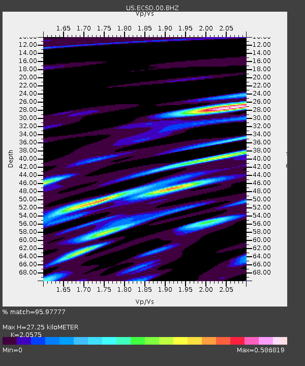
| Estimated Moho Depth: |
27.25 km |
| Estimated Crust Vp/Vs: |
2.06 |
| Assumed Crust Vp: |
6.498 km/s |
| Estimated Crust Vs: |
3.158 km/s |
| Estimated Crust Poisson's Ratio: |
0.35 |
|
| Radial Match: |
95.97777 % |
| Radial Bump: |
400 |
| Transverse Match: |
90.13797 % |
| Transverse Bump: |
400 |
| SOD ConfigId: |
512894 |
| Insert Time: |
2013-09-14 19:44:41.300 +0000 |
| GWidth: |
2.5 |
| Max Bumps: |
400 |
| Tol: |
0.001 |
|

Signal To Noise
| Channel | StoN | STA | LTA |
| US:ECSD:00:BHZ:20130524T15:05:58.44999Z | 64.50414 | 1.030344E-5 | 1.5973299E-7 |
| US:ECSD:00:BH1:20130524T15:05:58.44999Z | 27.453135 | 2.1244546E-6 | 7.7384776E-8 |
| US:ECSD:00:BH2:20130524T15:05:58.44999Z | 45.152756 | 3.9629304E-6 | 8.7767184E-8 |
| Arrivals |
| Ps | 4.6 SECOND |
| PpPs | 12 SECOND |
| PsPs/PpSs | 17 SECOND |


