You are here: Home > Network List > US - United States National Seismic Network Stations List
> Station LONY Lake Ozonia, New York, USA > Earthquake Result Viewer
LONY Lake Ozonia, New York, USA - Earthquake Result Viewer
| Earthquake location: |
Sea Of Okhotsk |
| Earthquake latitude/longitude: |
52.2/151.4 |
| Earthquake time(UTC): |
2013/05/24 (144) 14:56:31 GMT |
| Earthquake Depth: |
624 km |
| Earthquake Magnitude: |
6.7 MW, 6.7 MB, 6.7 MW |
| Earthquake Catalog/Contributor: |
NEIC PDE/NEIC PDE-W |
|
| Network: |
US United States National Seismic Network |
| Station: |
LONY Lake Ozonia, New York, USA |
| Lat/Lon: |
44.62 N/74.58 W |
| Elevation: |
440 m |
|
| Distance: |
75.7 deg |
| Az: |
32.031 deg |
| Baz: |
332.823 deg |
| Ray Param: |
0.04944128 |
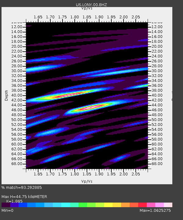
| Estimated Moho Depth: |
44.75 km |
| Estimated Crust Vp/Vs: |
1.87 |
| Assumed Crust Vp: |
6.419 km/s |
| Estimated Crust Vs: |
3.442 km/s |
| Estimated Crust Poisson's Ratio: |
0.30 |
|
| Radial Match: |
93.292885 % |
| Radial Bump: |
400 |
| Transverse Match: |
82.836426 % |
| Transverse Bump: |
400 |
| SOD ConfigId: |
512894 |
| Insert Time: |
2013-09-14 19:45:23.314 +0000 |
| GWidth: |
2.5 |
| Max Bumps: |
400 |
| Tol: |
0.001 |
|
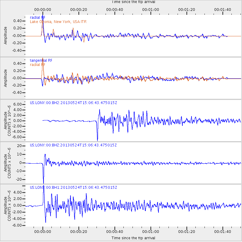
Signal To Noise
| Channel | StoN | STA | LTA |
| US:LONY:00:BHZ:20130524T15:06:43.475015Z | 39.81752 | 7.329241E-6 | 1.8407076E-7 |
| US:LONY:00:BH1:20130524T15:06:43.475015Z | 15.247894 | 2.3832388E-6 | 1.5629954E-7 |
| US:LONY:00:BH2:20130524T15:06:43.475015Z | 15.631664 | 2.3085238E-6 | 1.4768254E-7 |
| Arrivals |
| Ps | 6.2 SECOND |
| PpPs | 19 SECOND |
| PsPs/PpSs | 26 SECOND |


