You are here: Home > Network List > US - United States National Seismic Network Stations List
> Station WMOK Wichita Mountains, Oklahoma, USA > Earthquake Result Viewer
WMOK Wichita Mountains, Oklahoma, USA - Earthquake Result Viewer

| Earthquake location: |
Sea Of Okhotsk |
| Earthquake latitude/longitude: |
52.2/151.4 |
| Earthquake time(UTC): |
2013/05/24 (144) 14:56:31 GMT |
| Earthquake Depth: |
624 km |
| Earthquake Magnitude: |
6.7 MW, 6.7 MB, 6.7 MW |
| Earthquake Catalog/Contributor: |
NEIC PDE/NEIC PDE-W |
|
| Network: |
US United States National Seismic Network |
| Station: |
WMOK Wichita Mountains, Oklahoma, USA |
| Lat/Lon: |
34.74 N/98.78 W |
| Elevation: |
486 m |
|
| Distance: |
74.0 deg |
| Az: |
53.735 deg |
| Baz: |
322.979 deg |
| Ray Param: |
0.050546255 |
| Estimated Moho Depth: |
23.5 km |
| Estimated Crust Vp/Vs: |
1.75 |
| Assumed Crust Vp: |
6.315 km/s |
| Estimated Crust Vs: |
3.614 km/s |
| Estimated Crust Poisson's Ratio: |
0.26 |
|
| Radial Match: |
95.38107 % |
| Radial Bump: |
400 |
| Transverse Match: |
89.33511 % |
| Transverse Bump: |
400 |
| SOD ConfigId: |
512894 |
| Insert Time: |
2013-09-14 19:46:15.420 +0000 |
| GWidth: |
2.5 |
| Max Bumps: |
400 |
| Tol: |
0.001 |
|
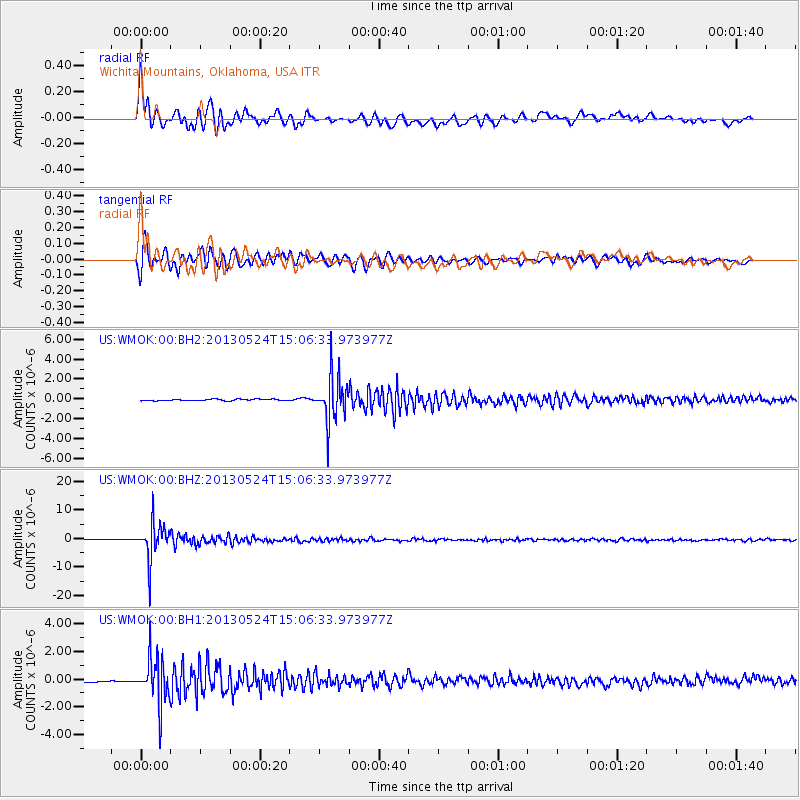
Signal To Noise
| Channel | StoN | STA | LTA |
| US:WMOK:00:BHZ:20130524T15:06:33.973977Z | 62.34994 | 6.307323E-6 | 1.01160055E-7 |
| US:WMOK:00:BH1:20130524T15:06:33.973977Z | 18.450352 | 1.6159867E-6 | 8.758568E-8 |
| US:WMOK:00:BH2:20130524T15:06:33.973977Z | 31.13626 | 2.3419955E-6 | 7.521763E-8 |
| Arrivals |
| Ps | 2.9 SECOND |
| PpPs | 9.9 SECOND |
| PsPs/PpSs | 13 SECOND |


