You are here: Home > Network List > UU - University of Utah Regional Network Stations List
> Station NOQ North Oquirrh Mountains, UT, USA > Earthquake Result Viewer
NOQ North Oquirrh Mountains, UT, USA - Earthquake Result Viewer
| Earthquake location: |
Sea Of Okhotsk |
| Earthquake latitude/longitude: |
52.2/151.4 |
| Earthquake time(UTC): |
2013/05/24 (144) 14:56:31 GMT |
| Earthquake Depth: |
624 km |
| Earthquake Magnitude: |
6.7 MW, 6.7 MB, 6.7 MW |
| Earthquake Catalog/Contributor: |
NEIC PDE/NEIC PDE-W |
|
| Network: |
UU University of Utah Regional Network |
| Station: |
NOQ North Oquirrh Mountains, UT, USA |
| Lat/Lon: |
40.65 N/112.12 W |
| Elevation: |
1622 m |
|
| Distance: |
62.7 deg |
| Az: |
58.333 deg |
| Baz: |
316.531 deg |
| Ray Param: |
0.05764014 |
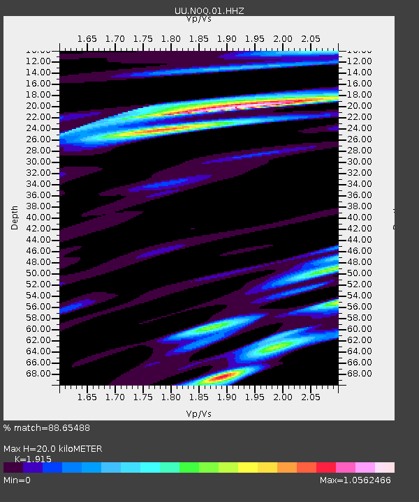
| Estimated Moho Depth: |
20.0 km |
| Estimated Crust Vp/Vs: |
1.91 |
| Assumed Crust Vp: |
6.276 km/s |
| Estimated Crust Vs: |
3.277 km/s |
| Estimated Crust Poisson's Ratio: |
0.31 |
|
| Radial Match: |
88.65488 % |
| Radial Bump: |
400 |
| Transverse Match: |
78.185776 % |
| Transverse Bump: |
400 |
| SOD ConfigId: |
512894 |
| Insert Time: |
2013-09-14 19:47:01.604 +0000 |
| GWidth: |
2.5 |
| Max Bumps: |
400 |
| Tol: |
0.001 |
|

Signal To Noise
| Channel | StoN | STA | LTA |
| UU:NOQ:01:HHZ:20130524T15:05:26.069985Z | 25.161037 | 1.5531258E-7 | 6.1727414E-9 |
| UU:NOQ:01:HHN:20130524T15:05:26.069985Z | 9.242353 | 5.9020124E-8 | 6.385833E-9 |
| UU:NOQ:01:HHE:20130524T15:05:26.069985Z | 10.534161 | 5.5043362E-8 | 5.225225E-9 |
| Arrivals |
| Ps | 3.0 SECOND |
| PpPs | 9.0 SECOND |
| PsPs/PpSs | 12 SECOND |


