You are here: Home > Network List > IU - Global Seismograph Network (GSN - IRIS/USGS) Stations List
> Station HNR Honiara, Solomon Islands > Earthquake Result Viewer
HNR Honiara, Solomon Islands - Earthquake Result Viewer
*The percent match for this event was below the threshold and hence no stack was calculated.
| Earthquake location: |
Banda Sea |
| Earthquake latitude/longitude: |
-7.5/127.9 |
| Earthquake time(UTC): |
2013/05/25 (145) 10:32:54 GMT |
| Earthquake Depth: |
100 km |
| Earthquake Magnitude: |
5.5 MW, 5.5 MW, 5.6 MB |
| Earthquake Catalog/Contributor: |
NEIC PDE/NEIC PDE-W |
|
| Network: |
IU Global Seismograph Network (GSN - IRIS/USGS) |
| Station: |
HNR Honiara, Solomon Islands |
| Lat/Lon: |
9.44 S/159.95 E |
| Elevation: |
100 m |
|
| Distance: |
31.7 deg |
| Az: |
95.777 deg |
| Baz: |
270.964 deg |
| Ray Param: |
$rayparam |
*The percent match for this event was below the threshold and hence was not used in the summary stack. |
|
| Radial Match: |
70.396416 % |
| Radial Bump: |
400 |
| Transverse Match: |
61.811325 % |
| Transverse Bump: |
400 |
| SOD ConfigId: |
512894 |
| Insert Time: |
2013-09-14 19:57:30.255 +0000 |
| GWidth: |
2.5 |
| Max Bumps: |
400 |
| Tol: |
0.001 |
|
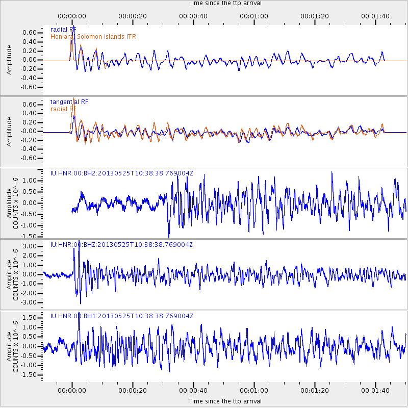
Signal To Noise
| Channel | StoN | STA | LTA |
| IU:HNR:00:BHZ:20130525T10:38:38.769004Z | 8.201606 | 1.5131708E-6 | 1.844969E-7 |
| IU:HNR:00:BH1:20130525T10:38:38.769004Z | 2.8927906 | 6.302727E-7 | 2.1787706E-7 |
| IU:HNR:00:BH2:20130525T10:38:38.769004Z | 2.9296021 | 5.641602E-7 | 1.9257227E-7 |
| Arrivals |
| Ps | |
| PpPs | |
| PsPs/PpSs | |


