You are here: Home > Network List > AK - Alaska Regional Network Stations List
> Station WAT4 Susitna Watana 4, AK, USA > Earthquake Result Viewer
WAT4 Susitna Watana 4, AK, USA - Earthquake Result Viewer
| Earthquake location: |
Southeastern Uzbekistan |
| Earthquake latitude/longitude: |
40.0/67.3 |
| Earthquake time(UTC): |
2013/05/26 (146) 06:08:15 GMT |
| Earthquake Depth: |
18 km |
| Earthquake Magnitude: |
5.7 MW, 5.6 MW, 5.9 MS, 6.2 MB |
| Earthquake Catalog/Contributor: |
NEIC PDE/NEIC PDE-W |
|
| Network: |
AK Alaska Regional Network |
| Station: |
WAT4 Susitna Watana 4, AK, USA |
| Lat/Lon: |
62.83 N/147.94 W |
| Elevation: |
1191 m |
|
| Distance: |
73.7 deg |
| Az: |
16.022 deg |
| Baz: |
332.47 deg |
| Ray Param: |
0.052795798 |
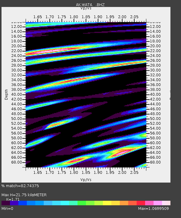
| Estimated Moho Depth: |
21.75 km |
| Estimated Crust Vp/Vs: |
1.71 |
| Assumed Crust Vp: |
6.566 km/s |
| Estimated Crust Vs: |
3.84 km/s |
| Estimated Crust Poisson's Ratio: |
0.24 |
|
| Radial Match: |
82.74375 % |
| Radial Bump: |
355 |
| Transverse Match: |
82.271355 % |
| Transverse Bump: |
400 |
| SOD ConfigId: |
512894 |
| Insert Time: |
2013-09-14 20:04:00.899 +0000 |
| GWidth: |
2.5 |
| Max Bumps: |
400 |
| Tol: |
0.001 |
|

Signal To Noise
| Channel | StoN | STA | LTA |
| AK:WAT4: :BHZ:20130526T06:19:17.488015Z | 26.193502 | 1.4057E-6 | 5.3665985E-8 |
| AK:WAT4: :BHN:20130526T06:19:17.488015Z | 9.4596815 | 4.8716834E-7 | 5.1499445E-8 |
| AK:WAT4: :BHE:20130526T06:19:17.488015Z | 10.789866 | 4.5342313E-7 | 4.2023053E-8 |
| Arrivals |
| Ps | 2.4 SECOND |
| PpPs | 8.7 SECOND |
| PsPs/PpSs | 11 SECOND |


