You are here: Home > Network List > PF - Volcanologic Network of Piton de Fournaise-OVPF Stations List
> Station FRE Station Sismologique des Fonds de la Riviere de l'Est > Earthquake Result Viewer
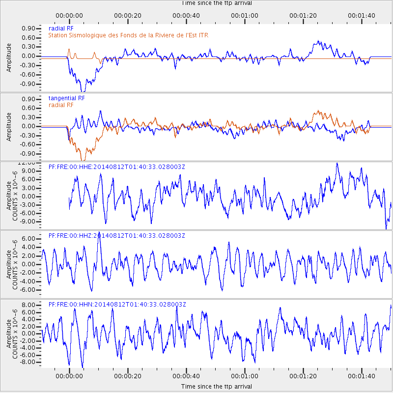
FRE Station Sismologique des Fonds de la Riviere de l'Est - Earthquake Result Viewer
*The percent match for this event was below the threshold and hence no stack was calculated.
| Earthquake location: |
New Ireland Region, P.N.G. |
| Earthquake latitude/longitude: |
-3.7/151.3 |
| Earthquake time(UTC): |
2014/08/12 (224) 01:28:31 GMT |
| Earthquake Depth: |
399 km |
| Earthquake Magnitude: |
5.2 MW, 5.1 mb |
| Earthquake Catalog/Contributor: |
ISC/ISC |
|
| Network: |
PF Volcanologic Network of Piton de Fournaise-OVPF |
| Station: |
FRE Station Sismologique des Fonds de la Riviere de l'Est |
| Lat/Lon: |
21.20 S/55.70 E |
| Elevation: |
1775 m |
|
| Distance: |
93.9 deg |
| Az: |
248.566 deg |
| Baz: |
95.421 deg |
| Ray Param: |
$rayparam |
*The percent match for this event was below the threshold and hence was not used in the summary stack. |
|
| Radial Match: |
29.948948 % |
| Radial Bump: |
400 |
| Transverse Match: |
46.620422 % |
| Transverse Bump: |
400 |
| SOD ConfigId: |
3390531 |
| Insert Time: |
2019-04-13 08:09:28.722 +0000 |
| GWidth: |
2.5 |
| Max Bumps: |
400 |
| Tol: |
0.001 |
|
Signal To Noise
| Channel | StoN | STA | LTA |
| PF:FRE:00:HHZ:20140812T01:40:33.028003Z | 0.9019894 | 2.116273E-6 | 2.3462283E-6 |
| PF:FRE:00:HHN:20140812T01:40:33.028003Z | 2.8605735 | 5.6190593E-6 | 1.964312E-6 |
| PF:FRE:00:HHE:20140812T01:40:33.028003Z | 0.7367842 | 2.9123403E-6 | 3.952772E-6 |
| Arrivals |
| Ps | |
| PpPs | |
| PsPs/PpSs | |


