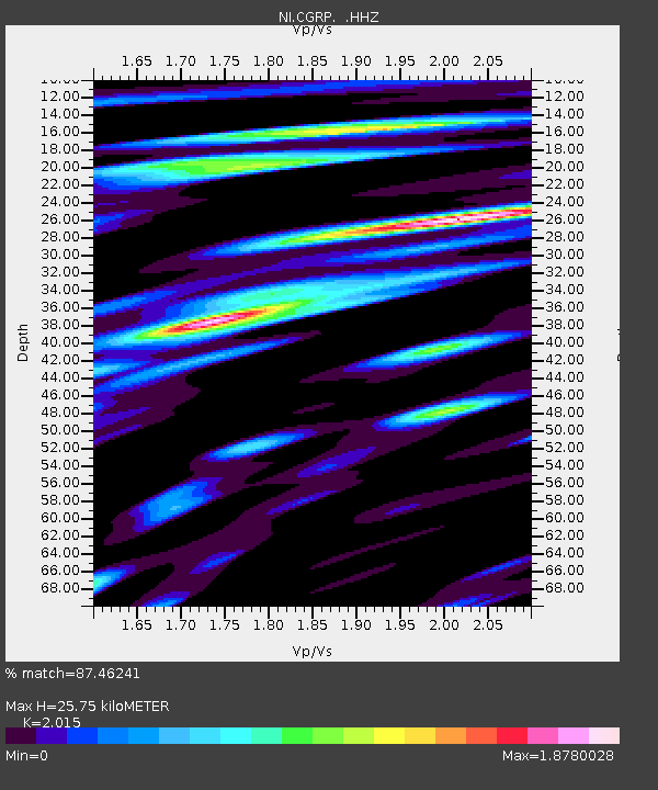
CGRP Cima Grappa - Earthquake Result Viewer
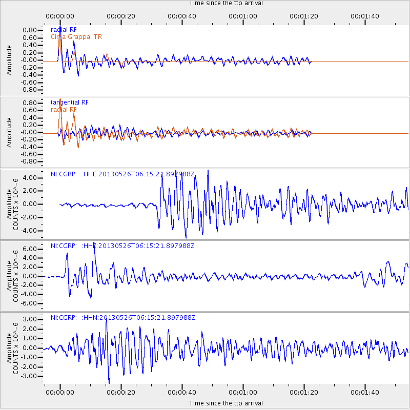
Earthquake location: Southeastern Uzbekistan
Earthquake latitude/longitude: 40.0/67.3
Earthquake time(UTC): 2013/05/26 (146) 06:08:15 GMT
Earthquake Depth: 18 km
Earthquake Magnitude: 5.7 MW, 5.6 MW, 5.9 MS, 6.2 MB
Earthquake Catalog/Contributor: NEIC PDE/NEIC PDE-W
Network: NI North-East Italy Broadband Network
Station: CGRP Cima Grappa
Lat/Lon: 45.88 N/11.80 E
Elevation: 1757 m
Distance: 40.4 deg
Az: 297.284 deg
Baz: 77.937 deg
Ray Param: 0.07441576
Estimated Moho Depth: 25.75 km
Estimated Crust Vp/Vs: 2.02
Assumed Crust Vp: 6.155 km/s
Estimated Crust Vs: 3.055 km/s
Estimated Crust Poisson's Ratio: 0.34
Radial Match: 87.46241 %
Radial Bump: 400
Transverse Match: 82.08191 %
Transverse Bump: 400
SOD ConfigId: 512894
Insert Time: 2013-09-14 20:16:47.255 +0000
GWidth: 2.5
Max Bumps: 400
Tol: 0.001

Signal To Noise

ChannelStoNSTALTA
NI:CGRP: :HHZ:20130526T06:15:21.897988Z24.277512.139522E-68.8127734E-8
NI:CGRP: :HHN:20130526T06:15:21.897988Z7.54729134.7870964E-76.3428004E-8
NI:CGRP: :HHE:20130526T06:15:21.897988Z13.3706281.782561E-61.3331916E-7
Arrivals
Ps4.5 SECOND
PpPs12 SECOND
PsPs/PpSs16 SECOND