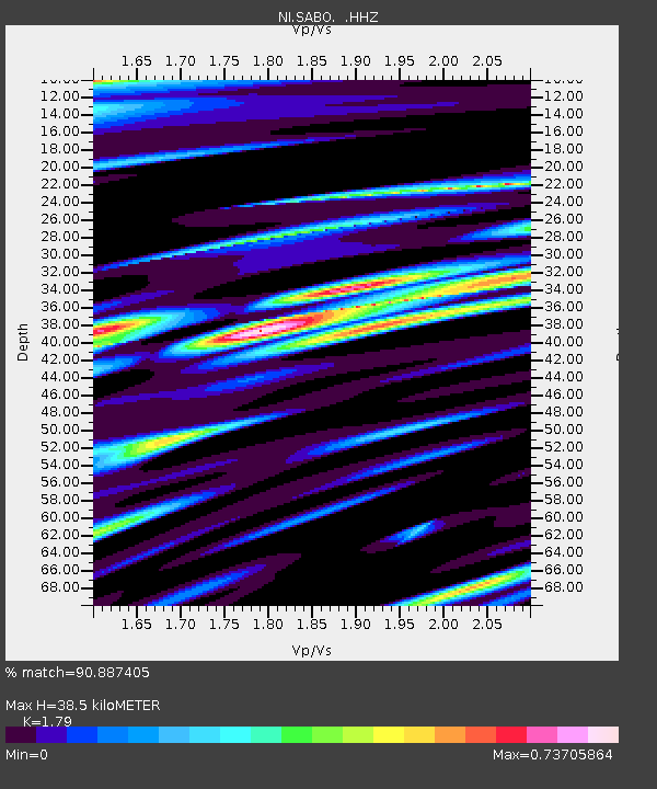
SABO Mt. Sabotino - Earthquake Result Viewer

Earthquake location: Southeastern Uzbekistan
Earthquake latitude/longitude: 40.0/67.3
Earthquake time(UTC): 2013/05/26 (146) 06:08:15 GMT
Earthquake Depth: 18 km
Earthquake Magnitude: 5.7 MW, 5.6 MW, 5.9 MS, 6.2 MB
Earthquake Catalog/Contributor: NEIC PDE/NEIC PDE-W
Network: NI North-East Italy Broadband Network
Station: SABO Mt. Sabotino
Lat/Lon: 45.99 N/13.63 E
Elevation: 621 m
Distance: 39.1 deg
Az: 297.05 deg
Baz: 79.067 deg
Ray Param: 0.07515507
Estimated Moho Depth: 38.5 km
Estimated Crust Vp/Vs: 1.79
Assumed Crust Vp: 6.207 km/s
Estimated Crust Vs: 3.467 km/s
Estimated Crust Poisson's Ratio: 0.27
Radial Match: 90.887405 %
Radial Bump: 400
Transverse Match: 84.571594 %
Transverse Bump: 400
SOD ConfigId: 512894
Insert Time: 2013-09-14 20:17:03.178 +0000
GWidth: 2.5
Max Bumps: 400
Tol: 0.001

Signal To Noise

ChannelStoNSTALTA
NI:SABO: :HHZ:20130526T06:15:11.337991Z23.204315.5483615E-62.391091E-7
NI:SABO: :HHN:20130526T06:15:11.337991Z5.89160971.373175E-62.3307298E-7
NI:SABO: :HHE:20130526T06:15:11.337991Z10.5275932.216183E-62.1051184E-7
Arrivals
Ps5.2 SECOND
PpPs16 SECOND
PsPs/PpSs21 SECOND