You are here: Home > Network List > IU - Global Seismograph Network (GSN - IRIS/USGS) Stations List
> Station POHA Pohakuloa, Hawaii, USA > Earthquake Result Viewer
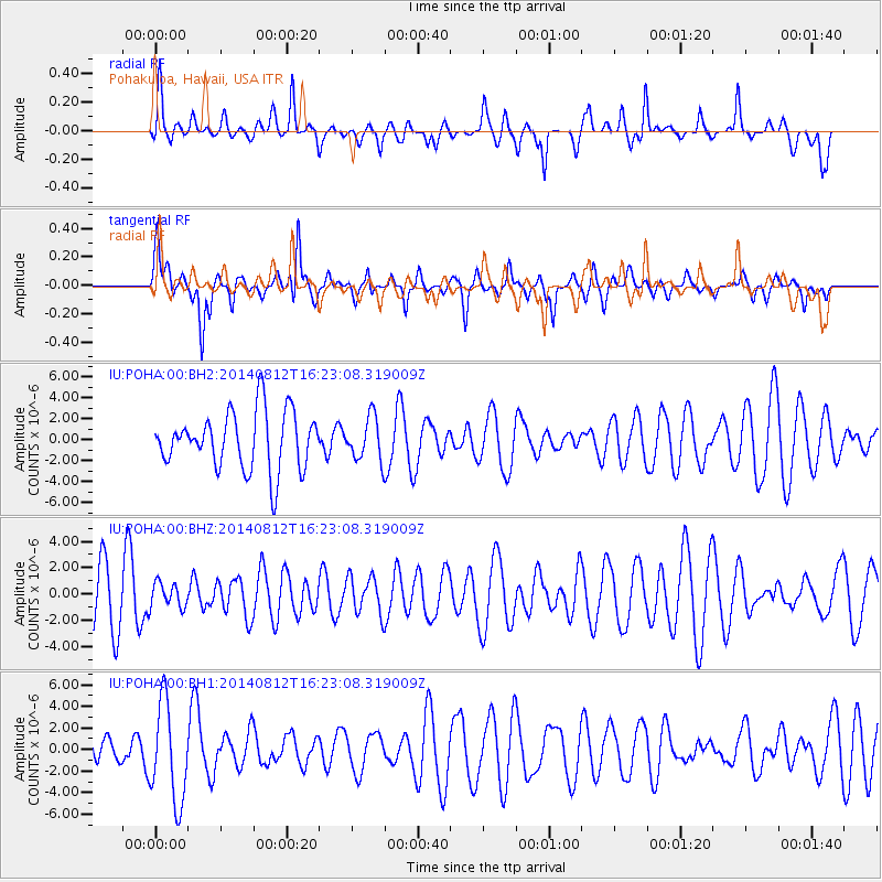
POHA Pohakuloa, Hawaii, USA - Earthquake Result Viewer
*The percent match for this event was below the threshold and hence no stack was calculated.
| Earthquake location: |
Samoa Islands Region |
| Earthquake latitude/longitude: |
-17.0/-172.9 |
| Earthquake time(UTC): |
2014/08/12 (224) 16:16:02 GMT |
| Earthquake Depth: |
10 km |
| Earthquake Magnitude: |
5.3 MW, 5.0 mb |
| Earthquake Catalog/Contributor: |
ISC/ISC |
|
| Network: |
IU Global Seismograph Network (GSN - IRIS/USGS) |
| Station: |
POHA Pohakuloa, Hawaii, USA |
| Lat/Lon: |
19.76 N/155.53 W |
| Elevation: |
1990 m |
|
| Distance: |
40.3 deg |
| Az: |
25.723 deg |
| Baz: |
206.17 deg |
| Ray Param: |
$rayparam |
*The percent match for this event was below the threshold and hence was not used in the summary stack. |
|
| Radial Match: |
48.809883 % |
| Radial Bump: |
363 |
| Transverse Match: |
54.839783 % |
| Transverse Bump: |
368 |
| SOD ConfigId: |
3390531 |
| Insert Time: |
2019-04-13 08:15:31.094 +0000 |
| GWidth: |
2.5 |
| Max Bumps: |
400 |
| Tol: |
0.001 |
|
Signal To Noise
| Channel | StoN | STA | LTA |
| IU:POHA:00:BHZ:20140812T16:23:08.319009Z | 0.40081748 | 9.468069E-7 | 2.3621894E-6 |
| IU:POHA:00:BH1:20140812T16:23:08.319009Z | 3.469534 | 4.586603E-6 | 1.3219652E-6 |
| IU:POHA:00:BH2:20140812T16:23:08.319009Z | 0.75504035 | 2.0704088E-6 | 2.7421167E-6 |
| Arrivals |
| Ps | |
| PpPs | |
| PsPs/PpSs | |


