You are here: Home > Network List > TA - USArray Transportable Network (new EarthScope stations) Stations List
> Station G42A Mountain, WI, USA > Earthquake Result Viewer
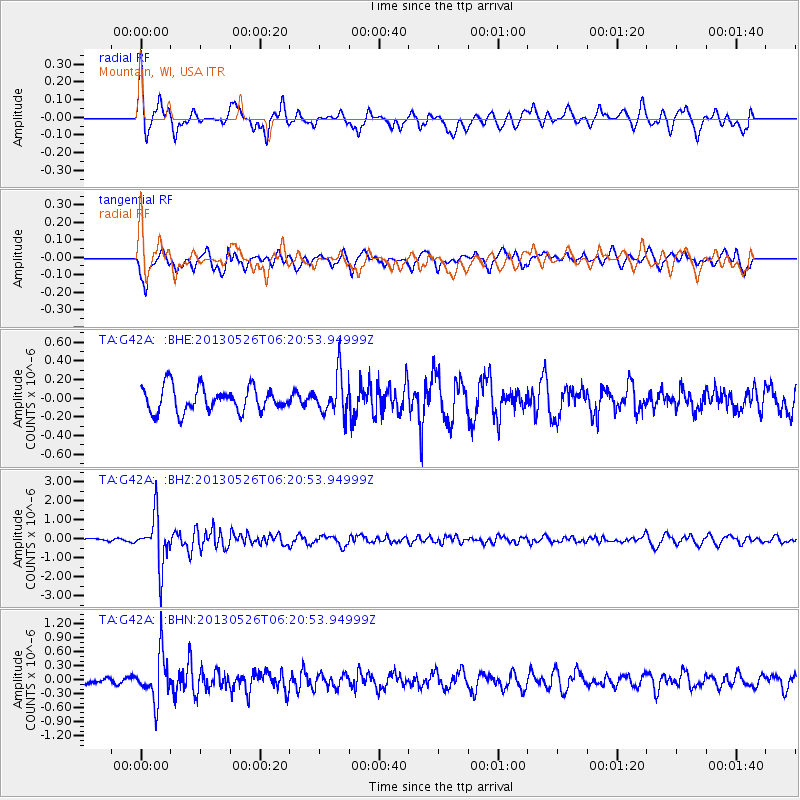
G42A Mountain, WI, USA - Earthquake Result Viewer
*The percent match for this event was below the threshold and hence no stack was calculated.
| Earthquake location: |
Southeastern Uzbekistan |
| Earthquake latitude/longitude: |
40.0/67.3 |
| Earthquake time(UTC): |
2013/05/26 (146) 06:08:15 GMT |
| Earthquake Depth: |
18 km |
| Earthquake Magnitude: |
5.7 MW, 5.6 MW, 5.9 MS, 6.2 MB |
| Earthquake Catalog/Contributor: |
NEIC PDE/NEIC PDE-W |
|
| Network: |
TA USArray Transportable Network (new EarthScope stations) |
| Station: |
G42A Mountain, WI, USA |
| Lat/Lon: |
45.24 N/88.43 W |
| Elevation: |
315 m |
|
| Distance: |
92.4 deg |
| Az: |
343.111 deg |
| Baz: |
18.426 deg |
| Ray Param: |
$rayparam |
*The percent match for this event was below the threshold and hence was not used in the summary stack. |
|
| Radial Match: |
77.781944 % |
| Radial Bump: |
386 |
| Transverse Match: |
62.410984 % |
| Transverse Bump: |
371 |
| SOD ConfigId: |
512894 |
| Insert Time: |
2013-09-14 20:22:53.455 +0000 |
| GWidth: |
2.5 |
| Max Bumps: |
400 |
| Tol: |
0.001 |
|
Signal To Noise
| Channel | StoN | STA | LTA |
| TA:G42A: :BHZ:20130526T06:20:53.94999Z | 8.614542 | 1.2937095E-6 | 1.5017739E-7 |
| TA:G42A: :BHN:20130526T06:20:53.94999Z | 4.264616 | 4.8369117E-7 | 1.1341963E-7 |
| TA:G42A: :BHE:20130526T06:20:53.94999Z | 1.5880395 | 2.0646438E-7 | 1.3001211E-7 |
| Arrivals |
| Ps | |
| PpPs | |
| PsPs/PpSs | |


