You are here: Home > Network List > CI - Caltech Regional Seismic Network Stations List
> Station SLA SLA, Trona, CA, USA > Earthquake Result Viewer
SLA SLA, Trona, CA, USA - Earthquake Result Viewer
| Earthquake location: |
Volcano Islands, Japan Region |
| Earthquake latitude/longitude: |
22.3/143.7 |
| Earthquake time(UTC): |
2000/03/28 (088) 11:00:22 GMT |
| Earthquake Depth: |
126 km |
| Earthquake Magnitude: |
6.8 MB, 7.6 MS, 7.6 MW, 7.6 MW |
| Earthquake Catalog/Contributor: |
WHDF/NEIC |
|
| Network: |
CI Caltech Regional Seismic Network |
| Station: |
SLA SLA, Trona, CA, USA |
| Lat/Lon: |
35.89 N/117.28 W |
| Elevation: |
1174 m |
|
| Distance: |
84.1 deg |
| Az: |
53.739 deg |
| Baz: |
293.163 deg |
| Ray Param: |
0.045452997 |
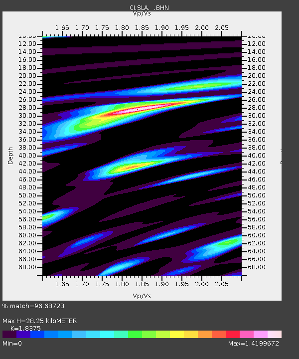
| Estimated Moho Depth: |
28.25 km |
| Estimated Crust Vp/Vs: |
1.84 |
| Assumed Crust Vp: |
6.276 km/s |
| Estimated Crust Vs: |
3.415 km/s |
| Estimated Crust Poisson's Ratio: |
0.29 |
|
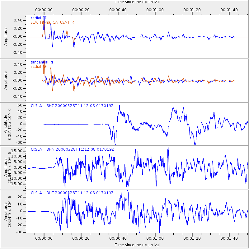
| Radial Match: |
96.68723 % |
| Radial Bump: |
400 |
| Transverse Match: |
89.759476 % |
| Transverse Bump: |
400 |
| SOD ConfigId: |
3744 |
| Insert Time: |
2010-02-25 20:34:04.658 +0000 |
| GWidth: |
2.5 |
| Max Bumps: |
400 |
| Tol: |
0.001 |
|
Signal To Noise
| Channel | StoN | STA | LTA |
| CI:SLA: :BHN:20000328T11:12:08.017019Z | 0.7601728 | 3.5126618E-7 | 4.6208729E-7 |
| CI:SLA: :BHE:20000328T11:12:08.017019Z | 1.1348332 | 4.7286596E-7 | 4.166832E-7 |
| CI:SLA: :BHZ:20000328T11:12:08.017019Z | 1.8415153 | 6.0591327E-7 | 3.2902972E-7 |
| Arrivals |
| Ps | 3.9 SECOND |
| PpPs | 12 SECOND |
| PsPs/PpSs | 16 SECOND |


