You are here: Home > Network List > TA - USArray Transportable Network (new EarthScope stations) Stations List
> Station H39A Augusta, WI, USA > Earthquake Result Viewer
H39A Augusta, WI, USA - Earthquake Result Viewer

| Earthquake location: |
Southeastern Uzbekistan |
| Earthquake latitude/longitude: |
40.0/67.3 |
| Earthquake time(UTC): |
2013/05/26 (146) 06:08:15 GMT |
| Earthquake Depth: |
18 km |
| Earthquake Magnitude: |
5.7 MW, 5.6 MW, 5.9 MS, 6.2 MB |
| Earthquake Catalog/Contributor: |
NEIC PDE/NEIC PDE-W |
|
| Network: |
TA USArray Transportable Network (new EarthScope stations) |
| Station: |
H39A Augusta, WI, USA |
| Lat/Lon: |
44.68 N/91.28 W |
| Elevation: |
345 m |
|
| Distance: |
93.6 deg |
| Az: |
344.88 deg |
| Baz: |
16.323 deg |
| Ray Param: |
0.041230697 |
| Estimated Moho Depth: |
25.0 km |
| Estimated Crust Vp/Vs: |
1.63 |
| Assumed Crust Vp: |
6.571 km/s |
| Estimated Crust Vs: |
4.025 km/s |
| Estimated Crust Poisson's Ratio: |
0.20 |
|
| Radial Match: |
84.488785 % |
| Radial Bump: |
400 |
| Transverse Match: |
72.055954 % |
| Transverse Bump: |
396 |
| SOD ConfigId: |
512894 |
| Insert Time: |
2013-09-14 20:23:21.622 +0000 |
| GWidth: |
2.5 |
| Max Bumps: |
400 |
| Tol: |
0.001 |
|
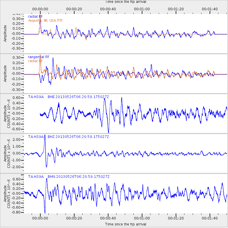
Signal To Noise
| Channel | StoN | STA | LTA |
| TA:H39A: :BHZ:20130526T06:20:59.175027Z | 4.761781 | 1.0909807E-6 | 2.291119E-7 |
| TA:H39A: :BHN:20130526T06:20:59.175027Z | 2.7938135 | 3.3558723E-7 | 1.2011799E-7 |
| TA:H39A: :BHE:20130526T06:20:59.175027Z | 0.65299785 | 1.01780905E-7 | 1.5586713E-7 |
| Arrivals |
| Ps | 2.5 SECOND |
| PpPs | 9.8 SECOND |
| PsPs/PpSs | 12 SECOND |


