You are here: Home > Network List > TA - USArray Transportable Network (new EarthScope stations) Stations List
> Station I48A Sherman Twp, MI, USA > Earthquake Result Viewer
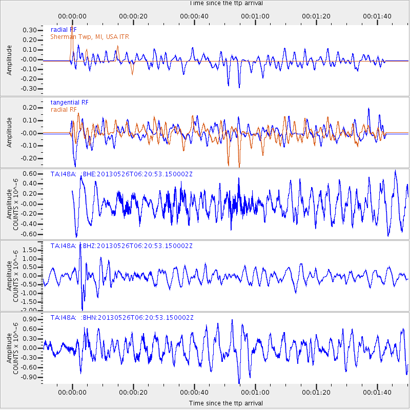
I48A Sherman Twp, MI, USA - Earthquake Result Viewer
*The percent match for this event was below the threshold and hence no stack was calculated.
| Earthquake location: |
Southeastern Uzbekistan |
| Earthquake latitude/longitude: |
40.0/67.3 |
| Earthquake time(UTC): |
2013/05/26 (146) 06:08:15 GMT |
| Earthquake Depth: |
18 km |
| Earthquake Magnitude: |
5.7 MW, 5.6 MW, 5.9 MS, 6.2 MB |
| Earthquake Catalog/Contributor: |
NEIC PDE/NEIC PDE-W |
|
| Network: |
TA USArray Transportable Network (new EarthScope stations) |
| Station: |
I48A Sherman Twp, MI, USA |
| Lat/Lon: |
44.19 N/83.70 W |
| Elevation: |
192 m |
|
| Distance: |
92.3 deg |
| Az: |
339.582 deg |
| Baz: |
21.885 deg |
| Ray Param: |
$rayparam |
*The percent match for this event was below the threshold and hence was not used in the summary stack. |
|
| Radial Match: |
60.027313 % |
| Radial Bump: |
400 |
| Transverse Match: |
71.990135 % |
| Transverse Bump: |
400 |
| SOD ConfigId: |
512894 |
| Insert Time: |
2013-09-14 20:24:42.774 +0000 |
| GWidth: |
2.5 |
| Max Bumps: |
400 |
| Tol: |
0.001 |
|
Signal To Noise
| Channel | StoN | STA | LTA |
| TA:I48A: :BHZ:20130526T06:20:53.150002Z | 2.3987234 | 8.193335E-7 | 3.4157063E-7 |
| TA:I48A: :BHN:20130526T06:20:53.150002Z | 1.680975 | 2.9931152E-7 | 1.780583E-7 |
| TA:I48A: :BHE:20130526T06:20:53.150002Z | 0.778876 | 1.8200528E-7 | 2.3367684E-7 |
| Arrivals |
| Ps | |
| PpPs | |
| PsPs/PpSs | |


