You are here: Home > Network List > TA - USArray Transportable Network (new EarthScope stations) Stations List
> Station J41A Loganville, WI, USA > Earthquake Result Viewer
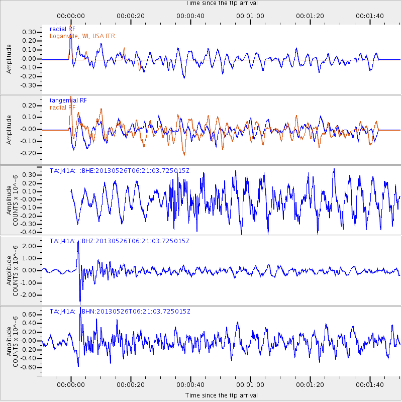
J41A Loganville, WI, USA - Earthquake Result Viewer
*The percent match for this event was below the threshold and hence no stack was calculated.
| Earthquake location: |
Southeastern Uzbekistan |
| Earthquake latitude/longitude: |
40.0/67.3 |
| Earthquake time(UTC): |
2013/05/26 (146) 06:08:15 GMT |
| Earthquake Depth: |
18 km |
| Earthquake Magnitude: |
5.7 MW, 5.6 MW, 5.9 MS, 6.2 MB |
| Earthquake Catalog/Contributor: |
NEIC PDE/NEIC PDE-W |
|
| Network: |
TA USArray Transportable Network (new EarthScope stations) |
| Station: |
J41A Loganville, WI, USA |
| Lat/Lon: |
43.37 N/90.01 W |
| Elevation: |
360 m |
|
| Distance: |
94.6 deg |
| Az: |
343.62 deg |
| Baz: |
17.291 deg |
| Ray Param: |
$rayparam |
*The percent match for this event was below the threshold and hence was not used in the summary stack. |
|
| Radial Match: |
61.673534 % |
| Radial Bump: |
400 |
| Transverse Match: |
57.174984 % |
| Transverse Bump: |
400 |
| SOD ConfigId: |
512894 |
| Insert Time: |
2013-09-14 20:25:22.460 +0000 |
| GWidth: |
2.5 |
| Max Bumps: |
400 |
| Tol: |
0.001 |
|
Signal To Noise
| Channel | StoN | STA | LTA |
| TA:J41A: :BHZ:20130526T06:21:03.725015Z | 5.261355 | 9.940328E-7 | 1.8893095E-7 |
| TA:J41A: :BHN:20130526T06:21:03.725015Z | 2.5493011 | 2.8916838E-7 | 1.13430445E-7 |
| TA:J41A: :BHE:20130526T06:21:03.725015Z | 0.9396506 | 1.2663111E-7 | 1.3476405E-7 |
| Arrivals |
| Ps | |
| PpPs | |
| PsPs/PpSs | |


