You are here: Home > Network List > TA - USArray Transportable Network (new EarthScope stations) Stations List
> Station J47A Sunmer, MI, USA > Earthquake Result Viewer
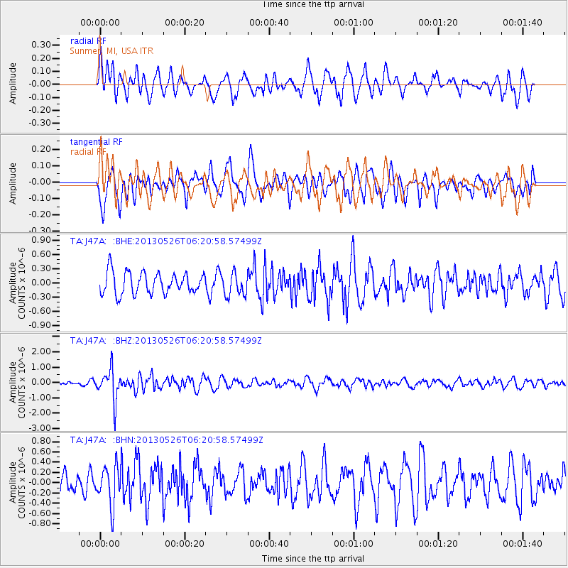
J47A Sunmer, MI, USA - Earthquake Result Viewer
*The percent match for this event was below the threshold and hence no stack was calculated.
| Earthquake location: |
Southeastern Uzbekistan |
| Earthquake latitude/longitude: |
40.0/67.3 |
| Earthquake time(UTC): |
2013/05/26 (146) 06:08:15 GMT |
| Earthquake Depth: |
18 km |
| Earthquake Magnitude: |
5.7 MW, 5.6 MW, 5.9 MS, 6.2 MB |
| Earthquake Catalog/Contributor: |
NEIC PDE/NEIC PDE-W |
|
| Network: |
TA USArray Transportable Network (new EarthScope stations) |
| Station: |
J47A Sunmer, MI, USA |
| Lat/Lon: |
43.24 N/84.82 W |
| Elevation: |
236 m |
|
| Distance: |
93.4 deg |
| Az: |
339.99 deg |
| Baz: |
21.094 deg |
| Ray Param: |
$rayparam |
*The percent match for this event was below the threshold and hence was not used in the summary stack. |
|
| Radial Match: |
64.07265 % |
| Radial Bump: |
400 |
| Transverse Match: |
59.427055 % |
| Transverse Bump: |
400 |
| SOD ConfigId: |
512894 |
| Insert Time: |
2013-09-14 20:25:35.086 +0000 |
| GWidth: |
2.5 |
| Max Bumps: |
400 |
| Tol: |
0.001 |
|
Signal To Noise
| Channel | StoN | STA | LTA |
| TA:J47A: :BHZ:20130526T06:20:58.57499Z | 6.8147516 | 1.0369907E-6 | 1.5216854E-7 |
| TA:J47A: :BHN:20130526T06:20:58.57499Z | 1.9946121 | 3.8490657E-7 | 1.9297315E-7 |
| TA:J47A: :BHE:20130526T06:20:58.57499Z | 1.0755638 | 2.4136094E-7 | 2.2440412E-7 |
| Arrivals |
| Ps | |
| PpPs | |
| PsPs/PpSs | |


