You are here: Home > Network List > TA - USArray Transportable Network (new EarthScope stations) Stations List
> Station M51A Elyria, OH, USA > Earthquake Result Viewer
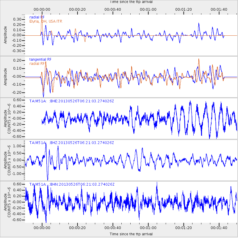
M51A Elyria, OH, USA - Earthquake Result Viewer
*The percent match for this event was below the threshold and hence no stack was calculated.
| Earthquake location: |
Southeastern Uzbekistan |
| Earthquake latitude/longitude: |
40.0/67.3 |
| Earthquake time(UTC): |
2013/05/26 (146) 06:08:15 GMT |
| Earthquake Depth: |
18 km |
| Earthquake Magnitude: |
5.7 MW, 5.6 MW, 5.9 MS, 6.2 MB |
| Earthquake Catalog/Contributor: |
NEIC PDE/NEIC PDE-W |
|
| Network: |
TA USArray Transportable Network (new EarthScope stations) |
| Station: |
M51A Elyria, OH, USA |
| Lat/Lon: |
41.33 N/82.18 W |
| Elevation: |
239 m |
|
| Distance: |
94.5 deg |
| Az: |
337.454 deg |
| Baz: |
23.038 deg |
| Ray Param: |
$rayparam |
*The percent match for this event was below the threshold and hence was not used in the summary stack. |
|
| Radial Match: |
49.46948 % |
| Radial Bump: |
400 |
| Transverse Match: |
72.14682 % |
| Transverse Bump: |
380 |
| SOD ConfigId: |
512894 |
| Insert Time: |
2013-09-14 20:28:19.365 +0000 |
| GWidth: |
2.5 |
| Max Bumps: |
400 |
| Tol: |
0.001 |
|
Signal To Noise
| Channel | StoN | STA | LTA |
| TA:M51A: :BHZ:20130526T06:21:03.274026Z | 3.1029446 | 6.3992303E-7 | 2.062309E-7 |
| TA:M51A: :BHN:20130526T06:21:03.274026Z | 1.2748338 | 3.017308E-7 | 2.3668248E-7 |
| TA:M51A: :BHE:20130526T06:21:03.274026Z | 1.2269473 | 1.4869673E-7 | 1.2119244E-7 |
| Arrivals |
| Ps | |
| PpPs | |
| PsPs/PpSs | |


