You are here: Home > Network List > UW - Pacific Northwest Regional Seismic Network Stations List
> Station BRAN Beach Ranch, Enterprise, OR, USA > Earthquake Result Viewer
BRAN Beach Ranch, Enterprise, OR, USA - Earthquake Result Viewer
| Earthquake location: |
Tonga Islands Region |
| Earthquake latitude/longitude: |
-23.0/-174.7 |
| Earthquake time(UTC): |
2009/03/19 (078) 18:17:40 GMT |
| Earthquake Depth: |
34 km |
| Earthquake Magnitude: |
7.0 MB, 7.6 MS, 7.6 MW, 7.6 MW |
| Earthquake Catalog/Contributor: |
WHDF/NEIC |
|
| Network: |
UW Pacific Northwest Regional Seismic Network |
| Station: |
BRAN Beach Ranch, Enterprise, OR, USA |
| Lat/Lon: |
45.97 N/117.23 W |
| Elevation: |
1136 m |
|
| Distance: |
86.2 deg |
| Az: |
36.09 deg |
| Baz: |
231.08 deg |
| Ray Param: |
0.0442001 |
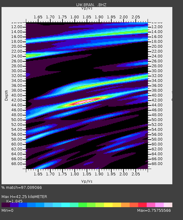
| Estimated Moho Depth: |
42.25 km |
| Estimated Crust Vp/Vs: |
1.85 |
| Assumed Crust Vp: |
6.571 km/s |
| Estimated Crust Vs: |
3.561 km/s |
| Estimated Crust Poisson's Ratio: |
0.29 |
|
| Radial Match: |
97.089066 % |
| Radial Bump: |
400 |
| Transverse Match: |
87.51065 % |
| Transverse Bump: |
400 |
| SOD ConfigId: |
2658 |
| Insert Time: |
2010-02-27 04:10:13.817 +0000 |
| GWidth: |
2.5 |
| Max Bumps: |
400 |
| Tol: |
0.001 |
|

Signal To Noise
| Channel | StoN | STA | LTA |
| UW:BRAN: :BHZ:20090319T18:29:47.449001Z | 23.882689 | 6.9549296E-6 | 2.9121216E-7 |
| UW:BRAN: :BHN:20090319T18:29:47.449001Z | 9.748416 | 1.3721713E-6 | 1.4075837E-7 |
| UW:BRAN: :BHE:20090319T18:29:47.449001Z | 11.080946 | 1.6973036E-6 | 1.5317316E-7 |
| Arrivals |
| Ps | 5.6 SECOND |
| PpPs | 18 SECOND |
| PsPs/PpSs | 23 SECOND |


