You are here: Home > Network List > US - United States National Seismic Network Stations List
> Station MSO Missoula, Montana, USA > Earthquake Result Viewer
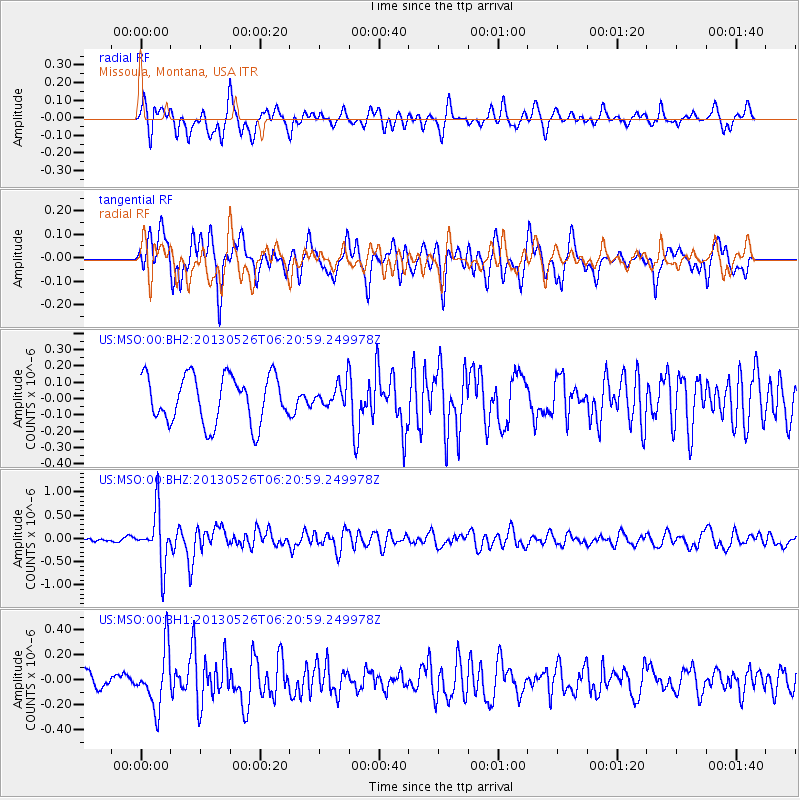
MSO Missoula, Montana, USA - Earthquake Result Viewer
*The percent match for this event was below the threshold and hence no stack was calculated.
| Earthquake location: |
Southeastern Uzbekistan |
| Earthquake latitude/longitude: |
40.0/67.3 |
| Earthquake time(UTC): |
2013/05/26 (146) 06:08:15 GMT |
| Earthquake Depth: |
18 km |
| Earthquake Magnitude: |
5.7 MW, 5.6 MW, 5.9 MS, 6.2 MB |
| Earthquake Catalog/Contributor: |
NEIC PDE/NEIC PDE-W |
|
| Network: |
US United States National Seismic Network |
| Station: |
MSO Missoula, Montana, USA |
| Lat/Lon: |
46.83 N/113.94 W |
| Elevation: |
1264 m |
|
| Distance: |
93.6 deg |
| Az: |
0.863 deg |
| Baz: |
359.034 deg |
| Ray Param: |
$rayparam |
*The percent match for this event was below the threshold and hence was not used in the summary stack. |
|
| Radial Match: |
59.71139 % |
| Radial Bump: |
383 |
| Transverse Match: |
59.45147 % |
| Transverse Bump: |
400 |
| SOD ConfigId: |
512894 |
| Insert Time: |
2013-09-14 20:34:38.587 +0000 |
| GWidth: |
2.5 |
| Max Bumps: |
400 |
| Tol: |
0.001 |
|
Signal To Noise
| Channel | StoN | STA | LTA |
| US:MSO:00:BHZ:20130526T06:20:59.249978Z | 8.716292 | 5.809132E-7 | 6.664683E-8 |
| US:MSO:00:BH1:20130526T06:20:59.249978Z | 4.579902 | 2.3074767E-7 | 5.0382667E-8 |
| US:MSO:00:BH2:20130526T06:20:59.249978Z | 0.49943787 | 7.2464466E-8 | 1.4509206E-7 |
| Arrivals |
| Ps | |
| PpPs | |
| PsPs/PpSs | |


