You are here: Home > Network List > IU - Global Seismograph Network (GSN - IRIS/USGS) Stations List
> Station JOHN Johnston Island, USA > Earthquake Result Viewer
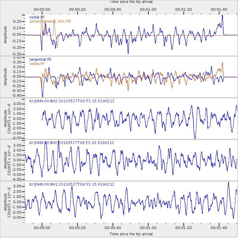
JOHN Johnston Island, USA - Earthquake Result Viewer
*The percent match for this event was below the threshold and hence no stack was calculated.
| Earthquake location: |
Panama-Costa Rica Border Region |
| Earthquake latitude/longitude: |
9.4/-82.6 |
| Earthquake time(UTC): |
2013/05/27 (147) 09:41:14 GMT |
| Earthquake Depth: |
9.2 km |
| Earthquake Magnitude: |
5.7 MW, 5.6 MB, 5.7 MW |
| Earthquake Catalog/Contributor: |
NEIC PDE/NEIC PDE-W |
|
| Network: |
IU Global Seismograph Network (GSN - IRIS/USGS) |
| Station: |
JOHN Johnston Island, USA |
| Lat/Lon: |
16.73 N/169.53 W |
| Elevation: |
2.0 m |
|
| Distance: |
84.4 deg |
| Az: |
285.974 deg |
| Baz: |
81.888 deg |
| Ray Param: |
$rayparam |
*The percent match for this event was below the threshold and hence was not used in the summary stack. |
|
| Radial Match: |
53.081997 % |
| Radial Bump: |
400 |
| Transverse Match: |
45.144955 % |
| Transverse Bump: |
400 |
| SOD ConfigId: |
512894 |
| Insert Time: |
2013-09-14 20:57:33.984 +0000 |
| GWidth: |
2.5 |
| Max Bumps: |
400 |
| Tol: |
0.001 |
|
Signal To Noise
| Channel | StoN | STA | LTA |
| IU:JOHN:00:BHZ:20130527T09:53:15.619021Z | 2.141153 | 2.274225E-6 | 1.0621496E-6 |
| IU:JOHN:00:BH1:20130527T09:53:15.619021Z | 0.8694496 | 8.3291104E-7 | 9.579751E-7 |
| IU:JOHN:00:BH2:20130527T09:53:15.619021Z | 0.95697796 | 1.1098602E-6 | 1.1597552E-6 |
| Arrivals |
| Ps | |
| PpPs | |
| PsPs/PpSs | |


