You are here: Home > Network List > TA - USArray Transportable Network (new EarthScope stations) Stations List
> Station F37A Hinrichs Farm, Grantsburg, WI, USA > Earthquake Result Viewer
F37A Hinrichs Farm, Grantsburg, WI, USA - Earthquake Result Viewer
| Earthquake location: |
Panama-Costa Rica Border Region |
| Earthquake latitude/longitude: |
9.4/-82.6 |
| Earthquake time(UTC): |
2013/05/27 (147) 09:41:14 GMT |
| Earthquake Depth: |
9.2 km |
| Earthquake Magnitude: |
5.7 MW, 5.6 MB, 5.7 MW |
| Earthquake Catalog/Contributor: |
NEIC PDE/NEIC PDE-W |
|
| Network: |
TA USArray Transportable Network (new EarthScope stations) |
| Station: |
F37A Hinrichs Farm, Grantsburg, WI, USA |
| Lat/Lon: |
45.72 N/92.63 W |
| Elevation: |
296 m |
|
| Distance: |
37.2 deg |
| Az: |
348.402 deg |
| Baz: |
163.55 deg |
| Ray Param: |
0.07627688 |
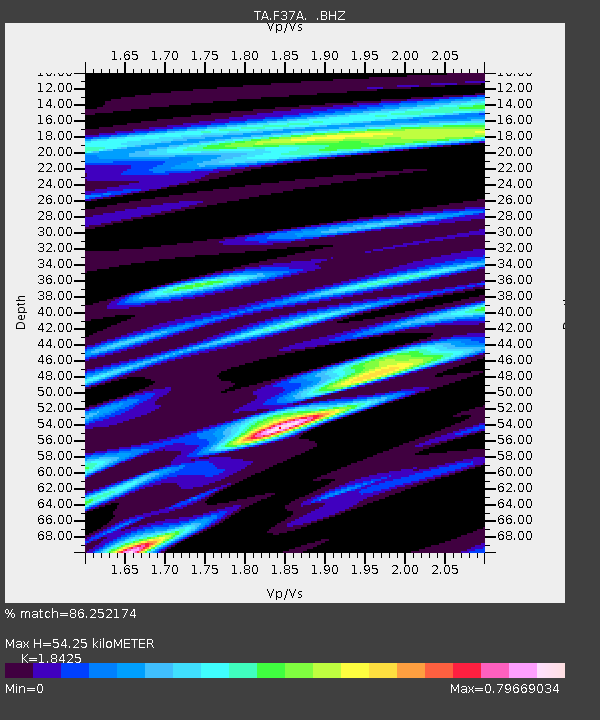
| Estimated Moho Depth: |
54.25 km |
| Estimated Crust Vp/Vs: |
1.84 |
| Assumed Crust Vp: |
6.571 km/s |
| Estimated Crust Vs: |
3.566 km/s |
| Estimated Crust Poisson's Ratio: |
0.29 |
|
| Radial Match: |
86.252174 % |
| Radial Bump: |
291 |
| Transverse Match: |
61.861954 % |
| Transverse Bump: |
400 |
| SOD ConfigId: |
512894 |
| Insert Time: |
2013-09-14 21:07:19.458 +0000 |
| GWidth: |
2.5 |
| Max Bumps: |
400 |
| Tol: |
0.001 |
|

Signal To Noise
| Channel | StoN | STA | LTA |
| TA:F37A: :BHZ:20130527T09:47:55.023989Z | 4.514245 | 4.1496662E-7 | 9.192381E-8 |
| TA:F37A: :BHN:20130527T09:47:55.023989Z | 2.9152079 | 2.7210527E-7 | 9.3339914E-8 |
| TA:F37A: :BHE:20130527T09:47:55.023989Z | 2.1121337 | 1.6984524E-7 | 8.0414054E-8 |
| Arrivals |
| Ps | 7.5 SECOND |
| PpPs | 22 SECOND |
| PsPs/PpSs | 29 SECOND |


