You are here: Home > Network List > TA - USArray Transportable Network (new EarthScope stations) Stations List
> Station G42A Mountain, WI, USA > Earthquake Result Viewer
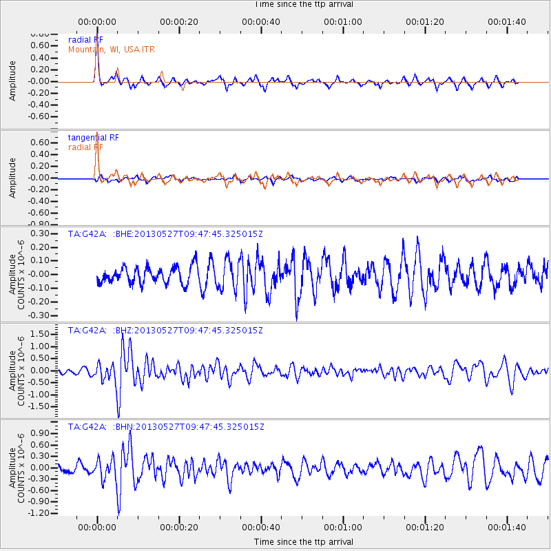
G42A Mountain, WI, USA - Earthquake Result Viewer
*The percent match for this event was below the threshold and hence no stack was calculated.
| Earthquake location: |
Panama-Costa Rica Border Region |
| Earthquake latitude/longitude: |
9.4/-82.6 |
| Earthquake time(UTC): |
2013/05/27 (147) 09:41:14 GMT |
| Earthquake Depth: |
9.2 km |
| Earthquake Magnitude: |
5.7 MW, 5.6 MB, 5.7 MW |
| Earthquake Catalog/Contributor: |
NEIC PDE/NEIC PDE-W |
|
| Network: |
TA USArray Transportable Network (new EarthScope stations) |
| Station: |
G42A Mountain, WI, USA |
| Lat/Lon: |
45.24 N/88.43 W |
| Elevation: |
315 m |
|
| Distance: |
36.0 deg |
| Az: |
353.043 deg |
| Baz: |
170.261 deg |
| Ray Param: |
$rayparam |
*The percent match for this event was below the threshold and hence was not used in the summary stack. |
|
| Radial Match: |
76.92235 % |
| Radial Bump: |
278 |
| Transverse Match: |
53.50736 % |
| Transverse Bump: |
400 |
| SOD ConfigId: |
512894 |
| Insert Time: |
2013-09-14 21:08:22.974 +0000 |
| GWidth: |
2.5 |
| Max Bumps: |
400 |
| Tol: |
0.001 |
|
Signal To Noise
| Channel | StoN | STA | LTA |
| TA:G42A: :BHZ:20130527T09:47:45.325015Z | 4.8472915 | 3.5833085E-7 | 7.392393E-8 |
| TA:G42A: :BHN:20130527T09:47:45.325015Z | 3.5440948 | 2.6621706E-7 | 7.511567E-8 |
| TA:G42A: :BHE:20130527T09:47:45.325015Z | 1.7956649 | 1.0599335E-7 | 5.9027354E-8 |
| Arrivals |
| Ps | |
| PpPs | |
| PsPs/PpSs | |


