You are here: Home > Network List > TA - USArray Transportable Network (new EarthScope stations) Stations List
> Station H17A Grant Village (NPS), Yellowstone Nt. Park, WY, USA > Earthquake Result Viewer
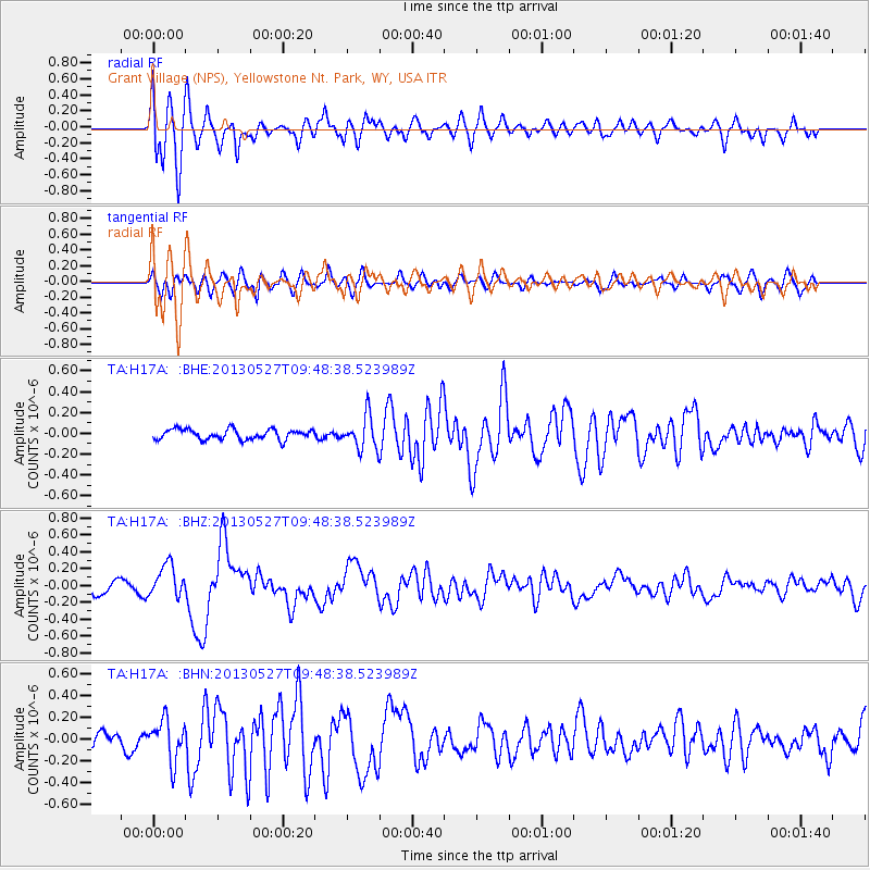
H17A Grant Village (NPS), Yellowstone Nt. Park, WY, USA - Earthquake Result Viewer
*The percent match for this event was below the threshold and hence no stack was calculated.
| Earthquake location: |
Panama-Costa Rica Border Region |
| Earthquake latitude/longitude: |
9.4/-82.6 |
| Earthquake time(UTC): |
2013/05/27 (147) 09:41:14 GMT |
| Earthquake Depth: |
9.2 km |
| Earthquake Magnitude: |
5.7 MW, 5.6 MB, 5.7 MW |
| Earthquake Catalog/Contributor: |
NEIC PDE/NEIC PDE-W |
|
| Network: |
TA USArray Transportable Network (new EarthScope stations) |
| Station: |
H17A Grant Village (NPS), Yellowstone Nt. Park, WY, USA |
| Lat/Lon: |
44.40 N/110.58 W |
| Elevation: |
2400 m |
|
| Distance: |
42.4 deg |
| Az: |
330.138 deg |
| Baz: |
136.739 deg |
| Ray Param: |
$rayparam |
*The percent match for this event was below the threshold and hence was not used in the summary stack. |
|
| Radial Match: |
71.327126 % |
| Radial Bump: |
400 |
| Transverse Match: |
67.76026 % |
| Transverse Bump: |
400 |
| SOD ConfigId: |
512894 |
| Insert Time: |
2013-09-14 21:08:42.964 +0000 |
| GWidth: |
2.5 |
| Max Bumps: |
400 |
| Tol: |
0.001 |
|
Signal To Noise
| Channel | StoN | STA | LTA |
| TA:H17A: :BHZ:20130527T09:48:38.523989Z | 2.7638469 | 1.9249097E-7 | 6.9646035E-8 |
| TA:H17A: :BHN:20130527T09:48:38.523989Z | 3.2057006 | 1.8513057E-7 | 5.7750423E-8 |
| TA:H17A: :BHE:20130527T09:48:38.523989Z | 3.169624 | 1.566934E-7 | 4.943596E-8 |
| Arrivals |
| Ps | |
| PpPs | |
| PsPs/PpSs | |


