You are here: Home > Network List > TA - USArray Transportable Network (new EarthScope stations) Stations List
> Station J45A Montague, MI, USA > Earthquake Result Viewer
J45A Montague, MI, USA - Earthquake Result Viewer
*The percent match for this event was below the threshold and hence no stack was calculated.
| Earthquake location: |
Panama-Costa Rica Border Region |
| Earthquake latitude/longitude: |
9.4/-82.6 |
| Earthquake time(UTC): |
2013/05/27 (147) 09:41:14 GMT |
| Earthquake Depth: |
9.2 km |
| Earthquake Magnitude: |
5.7 MW, 5.6 MB, 5.7 MW |
| Earthquake Catalog/Contributor: |
NEIC PDE/NEIC PDE-W |
|
| Network: |
TA USArray Transportable Network (new EarthScope stations) |
| Station: |
J45A Montague, MI, USA |
| Lat/Lon: |
43.44 N/86.39 W |
| Elevation: |
209 m |
|
| Distance: |
34.0 deg |
| Az: |
355.117 deg |
| Baz: |
173.38 deg |
| Ray Param: |
$rayparam |
*The percent match for this event was below the threshold and hence was not used in the summary stack. |
|
| Radial Match: |
69.953316 % |
| Radial Bump: |
400 |
| Transverse Match: |
57.71077 % |
| Transverse Bump: |
400 |
| SOD ConfigId: |
512894 |
| Insert Time: |
2013-09-14 21:10:25.775 +0000 |
| GWidth: |
2.5 |
| Max Bumps: |
400 |
| Tol: |
0.001 |
|
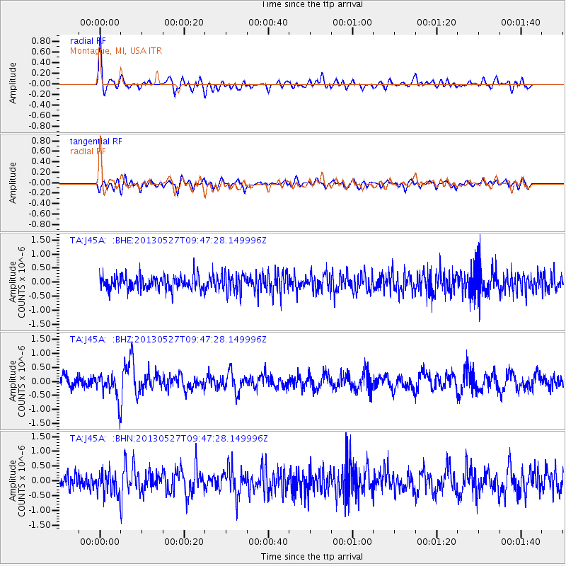
Signal To Noise
| Channel | StoN | STA | LTA |
| TA:J45A: :BHZ:20130527T09:47:28.149996Z | 2.4946961 | 4.67906E-7 | 1.8756032E-7 |
| TA:J45A: :BHN:20130527T09:47:28.149996Z | 1.433248 | 3.732556E-7 | 2.6042636E-7 |
| TA:J45A: :BHE:20130527T09:47:28.149996Z | 1.4120309 | 3.3426838E-7 | 2.367288E-7 |
| Arrivals |
| Ps | |
| PpPs | |
| PsPs/PpSs | |


