You are here: Home > Network List > TA - USArray Transportable Network (new EarthScope stations) Stations List
> Station M44A Midewin, Midewin Nat. Tallgrass Prarie, IL, USA > Earthquake Result Viewer
M44A Midewin, Midewin Nat. Tallgrass Prarie, IL, USA - Earthquake Result Viewer
| Earthquake location: |
Panama-Costa Rica Border Region |
| Earthquake latitude/longitude: |
9.4/-82.6 |
| Earthquake time(UTC): |
2013/05/27 (147) 09:41:14 GMT |
| Earthquake Depth: |
9.2 km |
| Earthquake Magnitude: |
5.7 MW, 5.6 MB, 5.7 MW |
| Earthquake Catalog/Contributor: |
NEIC PDE/NEIC PDE-W |
|
| Network: |
TA USArray Transportable Network (new EarthScope stations) |
| Station: |
M44A Midewin, Midewin Nat. Tallgrass Prarie, IL, USA |
| Lat/Lon: |
41.39 N/88.04 W |
| Elevation: |
207 m |
|
| Distance: |
32.2 deg |
| Az: |
352.356 deg |
| Baz: |
169.955 deg |
| Ray Param: |
0.078754514 |
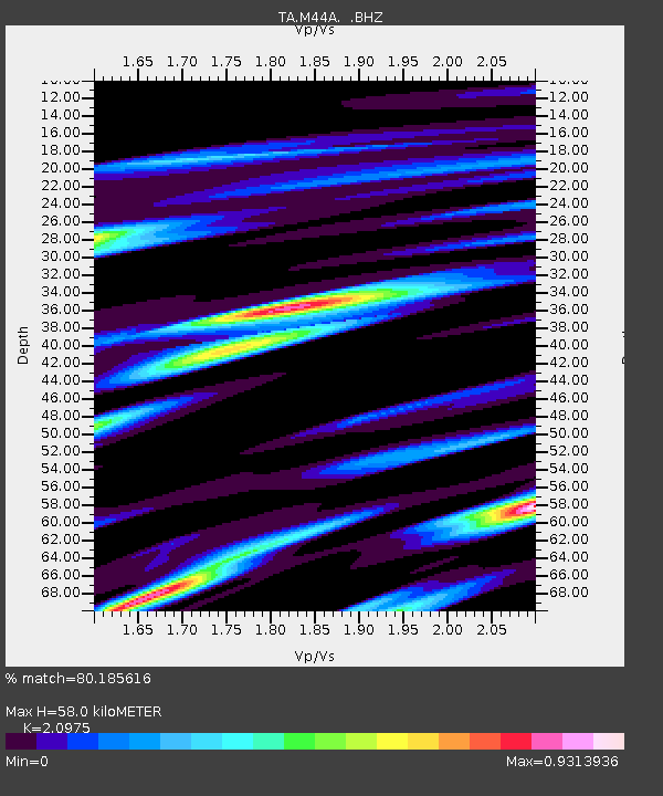
| Estimated Moho Depth: |
58.0 km |
| Estimated Crust Vp/Vs: |
2.10 |
| Assumed Crust Vp: |
6.498 km/s |
| Estimated Crust Vs: |
3.098 km/s |
| Estimated Crust Poisson's Ratio: |
0.35 |
|
| Radial Match: |
80.185616 % |
| Radial Bump: |
366 |
| Transverse Match: |
56.315887 % |
| Transverse Bump: |
400 |
| SOD ConfigId: |
512894 |
| Insert Time: |
2013-09-14 21:12:25.926 +0000 |
| GWidth: |
2.5 |
| Max Bumps: |
400 |
| Tol: |
0.001 |
|
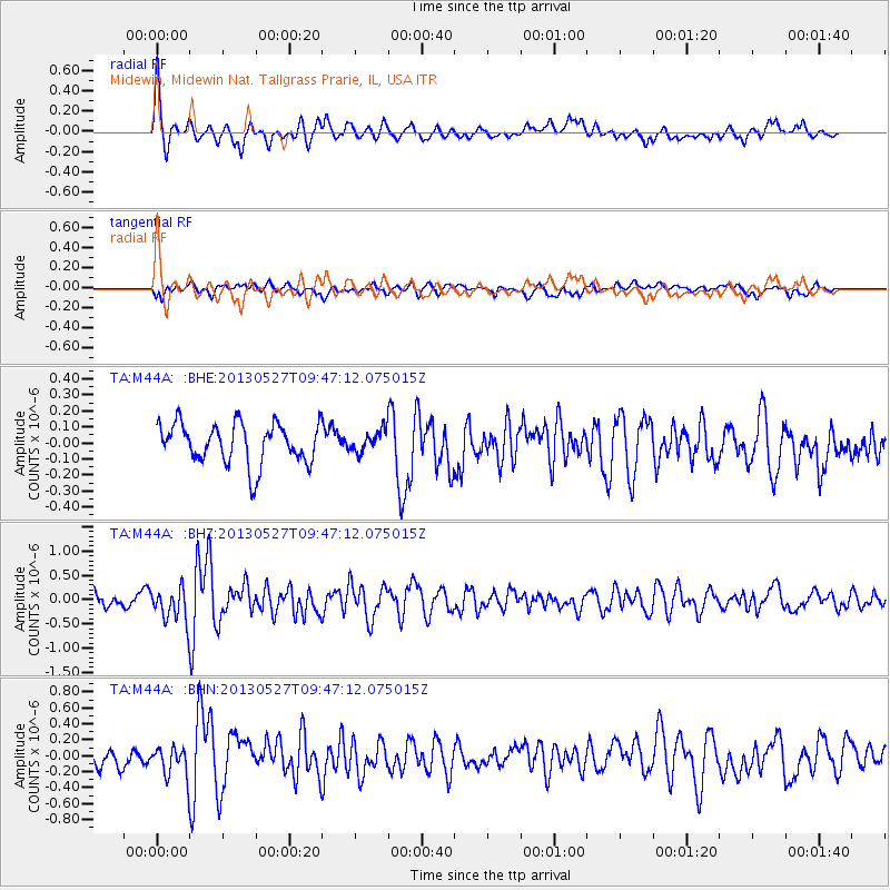
Signal To Noise
| Channel | StoN | STA | LTA |
| TA:M44A: :BHZ:20130527T09:47:12.075015Z | 2.7194364 | 3.4898306E-7 | 1.2832919E-7 |
| TA:M44A: :BHN:20130527T09:47:12.075015Z | 1.425867 | 1.8143331E-7 | 1.272442E-7 |
| TA:M44A: :BHE:20130527T09:47:12.075015Z | 0.5164536 | 6.477288E-8 | 1.2541858E-7 |
| Arrivals |
| Ps | 10 SECOND |
| PpPs | 26 SECOND |
| PsPs/PpSs | 36 SECOND |


