You are here: Home > Network List > TA - USArray Transportable Network (new EarthScope stations) Stations List
> Station M47A Cromwell, IN, USA > Earthquake Result Viewer
M47A Cromwell, IN, USA - Earthquake Result Viewer
| Earthquake location: |
Panama-Costa Rica Border Region |
| Earthquake latitude/longitude: |
9.4/-82.6 |
| Earthquake time(UTC): |
2013/05/27 (147) 09:41:14 GMT |
| Earthquake Depth: |
9.2 km |
| Earthquake Magnitude: |
5.7 MW, 5.6 MB, 5.7 MW |
| Earthquake Catalog/Contributor: |
NEIC PDE/NEIC PDE-W |
|
| Network: |
TA USArray Transportable Network (new EarthScope stations) |
| Station: |
M47A Cromwell, IN, USA |
| Lat/Lon: |
41.36 N/85.62 W |
| Elevation: |
283 m |
|
| Distance: |
31.9 deg |
| Az: |
355.751 deg |
| Baz: |
174.427 deg |
| Ray Param: |
0.078871995 |
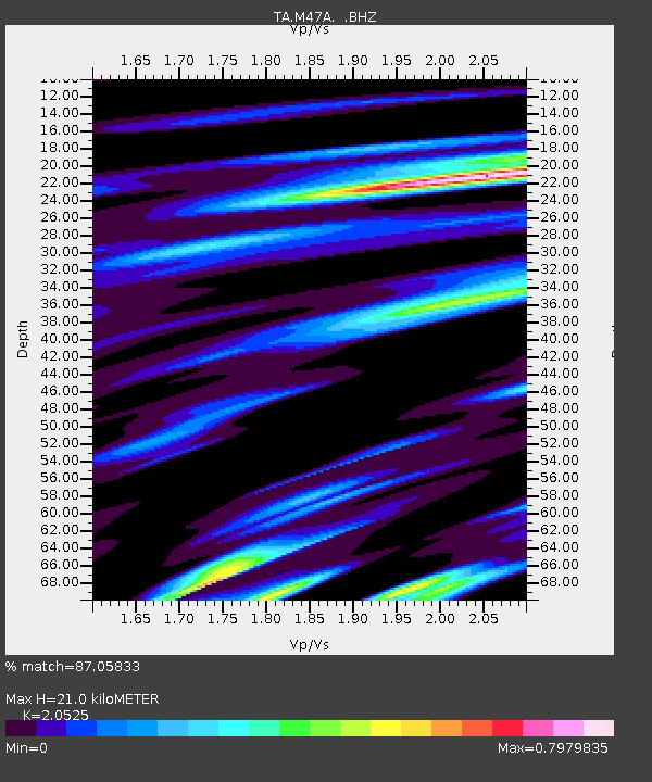
| Estimated Moho Depth: |
21.0 km |
| Estimated Crust Vp/Vs: |
2.05 |
| Assumed Crust Vp: |
6.498 km/s |
| Estimated Crust Vs: |
3.166 km/s |
| Estimated Crust Poisson's Ratio: |
0.34 |
|
| Radial Match: |
87.05833 % |
| Radial Bump: |
338 |
| Transverse Match: |
65.58537 % |
| Transverse Bump: |
400 |
| SOD ConfigId: |
512894 |
| Insert Time: |
2013-09-14 21:12:29.901 +0000 |
| GWidth: |
2.5 |
| Max Bumps: |
400 |
| Tol: |
0.001 |
|
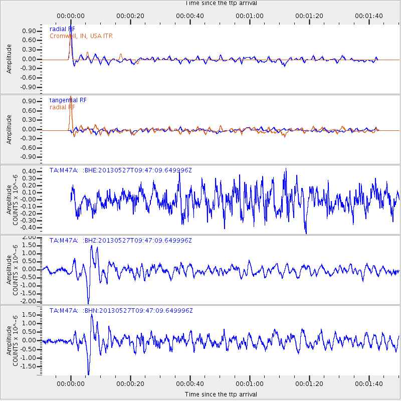
Signal To Noise
| Channel | StoN | STA | LTA |
| TA:M47A: :BHZ:20130527T09:47:09.649996Z | 3.3281748 | 3.4162983E-7 | 1.026478E-7 |
| TA:M47A: :BHN:20130527T09:47:09.649996Z | 1.9968888 | 2.4365792E-7 | 1.2201878E-7 |
| TA:M47A: :BHE:20130527T09:47:09.649996Z | 0.8947283 | 8.831217E-8 | 9.870278E-8 |
| Arrivals |
| Ps | 3.6 SECOND |
| PpPs | 9.2 SECOND |
| PsPs/PpSs | 13 SECOND |


