You are here: Home > Network List > TA - USArray Transportable Network (new EarthScope stations) Stations List
> Station N46A Monticello, IN, USA > Earthquake Result Viewer
N46A Monticello, IN, USA - Earthquake Result Viewer
| Earthquake location: |
Panama-Costa Rica Border Region |
| Earthquake latitude/longitude: |
9.4/-82.6 |
| Earthquake time(UTC): |
2013/05/27 (147) 09:41:14 GMT |
| Earthquake Depth: |
9.2 km |
| Earthquake Magnitude: |
5.7 MW, 5.6 MB, 5.7 MW |
| Earthquake Catalog/Contributor: |
NEIC PDE/NEIC PDE-W |
|
| Network: |
TA USArray Transportable Network (new EarthScope stations) |
| Station: |
N46A Monticello, IN, USA |
| Lat/Lon: |
40.89 N/86.74 W |
| Elevation: |
209 m |
|
| Distance: |
31.6 deg |
| Az: |
354.06 deg |
| Baz: |
172.259 deg |
| Ray Param: |
0.07902654 |
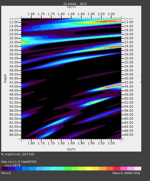
| Estimated Moho Depth: |
11.0 km |
| Estimated Crust Vp/Vs: |
2.10 |
| Assumed Crust Vp: |
6.498 km/s |
| Estimated Crust Vs: |
3.098 km/s |
| Estimated Crust Poisson's Ratio: |
0.35 |
|
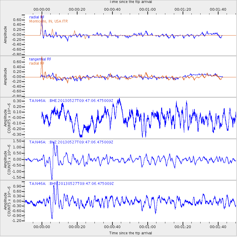
| Radial Match: |
81.557335 % |
| Radial Bump: |
363 |
| Transverse Match: |
49.60273 % |
| Transverse Bump: |
400 |
| SOD ConfigId: |
512894 |
| Insert Time: |
2013-09-14 21:13:09.837 +0000 |
| GWidth: |
2.5 |
| Max Bumps: |
400 |
| Tol: |
0.001 |
|
Signal To Noise
| Channel | StoN | STA | LTA |
| TA:N46A: :BHZ:20130527T09:47:06.475009Z | 3.6680055 | 2.486895E-7 | 6.7799654E-8 |
| TA:N46A: :BHN:20130527T09:47:06.475009Z | 1.6526377 | 1.415642E-7 | 8.565954E-8 |
| TA:N46A: :BHE:20130527T09:47:06.475009Z | 0.76550454 | 1.0863501E-7 | 1.4191295E-7 |
| Arrivals |
| Ps | 2.0 SECOND |
| PpPs | 4.9 SECOND |
| PsPs/PpSs | 6.9 SECOND |


