You are here: Home > Network List > TA - USArray Transportable Network (new EarthScope stations) Stations List
> Station N48A Decatur, IN, USA > Earthquake Result Viewer
N48A Decatur, IN, USA - Earthquake Result Viewer

| Earthquake location: |
Panama-Costa Rica Border Region |
| Earthquake latitude/longitude: |
9.4/-82.6 |
| Earthquake time(UTC): |
2013/05/27 (147) 09:41:14 GMT |
| Earthquake Depth: |
9.2 km |
| Earthquake Magnitude: |
5.7 MW, 5.6 MB, 5.7 MW |
| Earthquake Catalog/Contributor: |
NEIC PDE/NEIC PDE-W |
|
| Network: |
TA USArray Transportable Network (new EarthScope stations) |
| Station: |
N48A Decatur, IN, USA |
| Lat/Lon: |
40.86 N/85.03 W |
| Elevation: |
250 m |
|
| Distance: |
31.4 deg |
| Az: |
356.519 deg |
| Baz: |
175.47 deg |
| Ray Param: |
0.079083905 |
| Estimated Moho Depth: |
49.0 km |
| Estimated Crust Vp/Vs: |
1.60 |
| Assumed Crust Vp: |
6.498 km/s |
| Estimated Crust Vs: |
4.061 km/s |
| Estimated Crust Poisson's Ratio: |
0.18 |
|
| Radial Match: |
85.35888 % |
| Radial Bump: |
373 |
| Transverse Match: |
68.96572 % |
| Transverse Bump: |
400 |
| SOD ConfigId: |
512894 |
| Insert Time: |
2013-09-14 21:13:14.971 +0000 |
| GWidth: |
2.5 |
| Max Bumps: |
400 |
| Tol: |
0.001 |
|
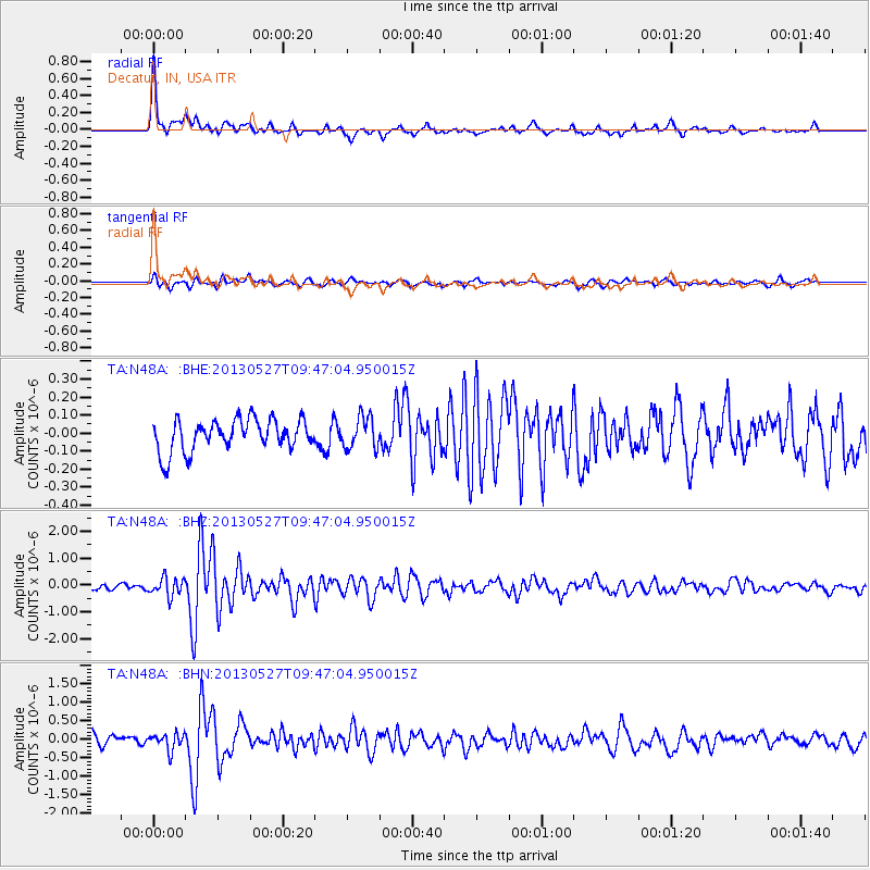
Signal To Noise
| Channel | StoN | STA | LTA |
| TA:N48A: :BHZ:20130527T09:47:04.950015Z | 3.6838245 | 3.416162E-7 | 9.2734105E-8 |
| TA:N48A: :BHN:20130527T09:47:04.950015Z | 1.3769199 | 2.2774255E-7 | 1.6540001E-7 |
| TA:N48A: :BHE:20130527T09:47:04.950015Z | 1.0086988 | 8.8186546E-8 | 8.742604E-8 |
| Arrivals |
| Ps | 5.0 SECOND |
| PpPs | 18 SECOND |
| PsPs/PpSs | 23 SECOND |


