You are here: Home > Network List > TA - USArray Transportable Network (new EarthScope stations) Stations List
> Station O44A Mansfield, IL, USA > Earthquake Result Viewer
O44A Mansfield, IL, USA - Earthquake Result Viewer

| Earthquake location: |
Panama-Costa Rica Border Region |
| Earthquake latitude/longitude: |
9.4/-82.6 |
| Earthquake time(UTC): |
2013/05/27 (147) 09:41:14 GMT |
| Earthquake Depth: |
9.2 km |
| Earthquake Magnitude: |
5.7 MW, 5.6 MB, 5.7 MW |
| Earthquake Catalog/Contributor: |
NEIC PDE/NEIC PDE-W |
|
| Network: |
TA USArray Transportable Network (new EarthScope stations) |
| Station: |
O44A Mansfield, IL, USA |
| Lat/Lon: |
40.15 N/88.47 W |
| Elevation: |
213 m |
|
| Distance: |
31.0 deg |
| Az: |
351.319 deg |
| Baz: |
168.796 deg |
| Ray Param: |
0.079173274 |
| Estimated Moho Depth: |
20.0 km |
| Estimated Crust Vp/Vs: |
1.79 |
| Assumed Crust Vp: |
6.498 km/s |
| Estimated Crust Vs: |
3.63 km/s |
| Estimated Crust Poisson's Ratio: |
0.27 |
|
| Radial Match: |
87.558846 % |
| Radial Bump: |
400 |
| Transverse Match: |
71.12955 % |
| Transverse Bump: |
400 |
| SOD ConfigId: |
512894 |
| Insert Time: |
2013-09-14 21:13:49.302 +0000 |
| GWidth: |
2.5 |
| Max Bumps: |
400 |
| Tol: |
0.001 |
|
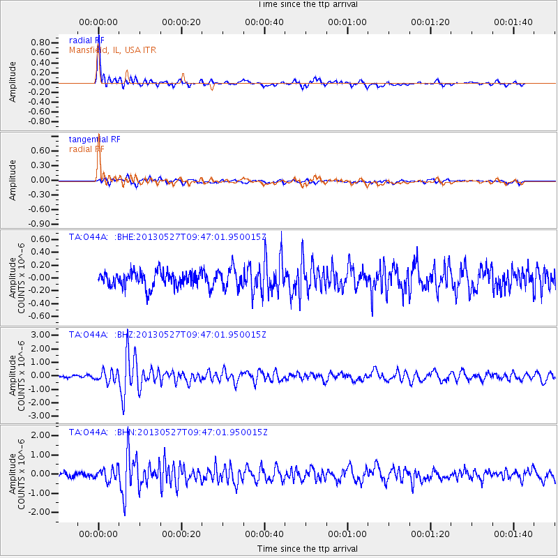
Signal To Noise
| Channel | StoN | STA | LTA |
| TA:O44A: :BHZ:20130527T09:47:01.950015Z | 4.1403856 | 4.093203E-7 | 9.8860426E-8 |
| TA:O44A: :BHN:20130527T09:47:01.950015Z | 3.5079522 | 3.2529465E-7 | 9.273063E-8 |
| TA:O44A: :BHE:20130527T09:47:01.950015Z | 1.3438518 | 1.5544218E-7 | 1.1566913E-7 |
| Arrivals |
| Ps | 2.6 SECOND |
| PpPs | 7.9 SECOND |
| PsPs/PpSs | 11 SECOND |


