You are here: Home > Network List > TA - USArray Transportable Network (new EarthScope stations) Stations List
> Station R11A Troy Canyon, Currant, NV, USA > Earthquake Result Viewer
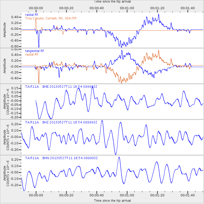
R11A Troy Canyon, Currant, NV, USA - Earthquake Result Viewer
*The percent match for this event was below the threshold and hence no stack was calculated.
| Earthquake location: |
Pacific-Antarctic Ridge |
| Earthquake latitude/longitude: |
-54.2/-135.8 |
| Earthquake time(UTC): |
2013/05/27 (147) 11:06:08 GMT |
| Earthquake Depth: |
10 km |
| Earthquake Magnitude: |
5.6 MW |
| Earthquake Catalog/Contributor: |
NEIC PDE/NEIC PDE-W |
|
| Network: |
TA USArray Transportable Network (new EarthScope stations) |
| Station: |
R11A Troy Canyon, Currant, NV, USA |
| Lat/Lon: |
38.35 N/115.59 W |
| Elevation: |
1756 m |
|
| Distance: |
93.8 deg |
| Az: |
15.815 deg |
| Baz: |
191.745 deg |
| Ray Param: |
$rayparam |
*The percent match for this event was below the threshold and hence was not used in the summary stack. |
|
| Radial Match: |
57.744946 % |
| Radial Bump: |
400 |
| Transverse Match: |
48.597416 % |
| Transverse Bump: |
400 |
| SOD ConfigId: |
512894 |
| Insert Time: |
2013-09-14 21:33:01.891 +0000 |
| GWidth: |
2.5 |
| Max Bumps: |
400 |
| Tol: |
0.001 |
|
Signal To Noise
| Channel | StoN | STA | LTA |
| TA:R11A: :BHZ:20130527T11:18:54.099993Z | 0.41771394 | 2.7389161E-8 | 6.556918E-8 |
| TA:R11A: :BHN:20130527T11:18:54.099993Z | 1.3128006 | 2.2460331E-7 | 1.7108714E-7 |
| TA:R11A: :BHE:20130527T11:18:54.099993Z | 1.1989107 | 1.1061306E-7 | 9.22613E-8 |
| Arrivals |
| Ps | |
| PpPs | |
| PsPs/PpSs | |


