You are here: Home > Network List > IU - Global Seismograph Network (GSN - IRIS/USGS) Stations List
> Station PMG Port Moresby, New Guinea > Earthquake Result Viewer
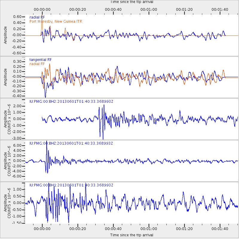
PMG Port Moresby, New Guinea - Earthquake Result Viewer
*The percent match for this event was below the threshold and hence no stack was calculated.
| Earthquake location: |
South Of Fiji Islands |
| Earthquake latitude/longitude: |
-23.1/-177.2 |
| Earthquake time(UTC): |
2013/06/01 (152) 01:34:14 GMT |
| Earthquake Depth: |
185 km |
| Earthquake Magnitude: |
5.5 MB |
| Earthquake Catalog/Contributor: |
NEIC PDE/NEIC PDE-W |
|
| Network: |
IU Global Seismograph Network (GSN - IRIS/USGS) |
| Station: |
PMG Port Moresby, New Guinea |
| Lat/Lon: |
9.40 S/147.16 E |
| Elevation: |
90 m |
|
| Distance: |
36.7 deg |
| Az: |
285.8 deg |
| Baz: |
116.084 deg |
| Ray Param: |
$rayparam |
*The percent match for this event was below the threshold and hence was not used in the summary stack. |
|
| Radial Match: |
54.15341 % |
| Radial Bump: |
400 |
| Transverse Match: |
50.528725 % |
| Transverse Bump: |
400 |
| SOD ConfigId: |
512894 |
| Insert Time: |
2013-09-14 21:48:12.409 +0000 |
| GWidth: |
2.5 |
| Max Bumps: |
400 |
| Tol: |
0.001 |
|
Signal To Noise
| Channel | StoN | STA | LTA |
| IU:PMG:00:BHZ:20130601T01:40:33.368993Z | 8.409388 | 2.4340507E-6 | 2.8944447E-7 |
| IU:PMG:00:BH1:20130601T01:40:33.368993Z | 2.0301273 | 5.9020266E-7 | 2.9072197E-7 |
| IU:PMG:00:BH2:20130601T01:40:33.368993Z | 4.959979 | 1.14128E-6 | 2.3009773E-7 |
| Arrivals |
| Ps | |
| PpPs | |
| PsPs/PpSs | |


