You are here: Home > Network List > WY - Yellowstone Wyoming Seismic Network Stations List
> Station YHH Holmes Hill, YNP, WY, USA > Earthquake Result Viewer
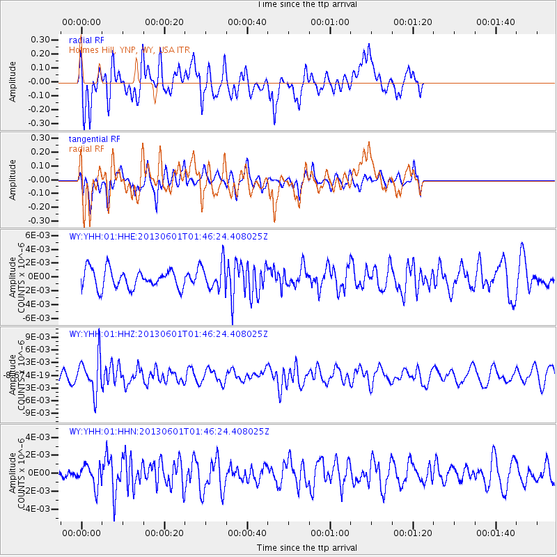
YHH Holmes Hill, YNP, WY, USA - Earthquake Result Viewer
*The percent match for this event was below the threshold and hence no stack was calculated.
| Earthquake location: |
South Of Fiji Islands |
| Earthquake latitude/longitude: |
-23.1/-177.2 |
| Earthquake time(UTC): |
2013/06/01 (152) 01:34:14 GMT |
| Earthquake Depth: |
185 km |
| Earthquake Magnitude: |
5.5 MB |
| Earthquake Catalog/Contributor: |
NEIC PDE/NEIC PDE-W |
|
| Network: |
WY Yellowstone Wyoming Seismic Network |
| Station: |
YHH Holmes Hill, YNP, WY, USA |
| Lat/Lon: |
44.79 N/110.85 W |
| Elevation: |
2717 m |
|
| Distance: |
90.6 deg |
| Az: |
40.71 deg |
| Baz: |
237.524 deg |
| Ray Param: |
$rayparam |
*The percent match for this event was below the threshold and hence was not used in the summary stack. |
|
| Radial Match: |
59.939766 % |
| Radial Bump: |
400 |
| Transverse Match: |
50.337917 % |
| Transverse Bump: |
331 |
| SOD ConfigId: |
512894 |
| Insert Time: |
2013-09-14 21:57:33.804 +0000 |
| GWidth: |
2.5 |
| Max Bumps: |
400 |
| Tol: |
0.001 |
|
Signal To Noise
| Channel | StoN | STA | LTA |
| WY:YHH:01:HHZ:20130601T01:46:24.408025Z | 2.857221 | 4.369594E-9 | 1.5293161E-9 |
| WY:YHH:01:HHN:20130601T01:46:24.408025Z | 1.088506 | 1.2430101E-9 | 1.1419415E-9 |
| WY:YHH:01:HHE:20130601T01:46:24.408025Z | 1.3797581 | 1.882336E-9 | 1.3642507E-9 |
| Arrivals |
| Ps | |
| PpPs | |
| PsPs/PpSs | |


