You are here: Home > Network List > CB - China National Seismic Network Stations List
> Station XLT Xilinhaote,Neimeng Province > Earthquake Result Viewer
XLT Xilinhaote,Neimeng Province - Earthquake Result Viewer
| Earthquake location: |
Mindanao, Philippines |
| Earthquake latitude/longitude: |
7.3/124.9 |
| Earthquake time(UTC): |
2013/06/01 (152) 14:10:06 GMT |
| Earthquake Depth: |
10 km |
| Earthquake Magnitude: |
5.6 MW, 5.6 MW, 5.7 MB |
| Earthquake Catalog/Contributor: |
NEIC PDE/NEIC PDE-W |
|
| Network: |
CB China National Seismic Network |
| Station: |
XLT Xilinhaote,Neimeng Province |
| Lat/Lon: |
43.90 N/116.08 E |
| Elevation: |
1030 m |
|
| Distance: |
37.3 deg |
| Az: |
349.46 deg |
| Baz: |
165.461 deg |
| Ray Param: |
0.07621637 |
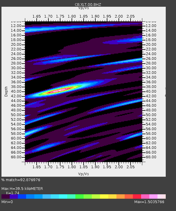
| Estimated Moho Depth: |
39.5 km |
| Estimated Crust Vp/Vs: |
1.74 |
| Assumed Crust Vp: |
6.459 km/s |
| Estimated Crust Vs: |
3.712 km/s |
| Estimated Crust Poisson's Ratio: |
0.25 |
|
| Radial Match: |
92.876976 % |
| Radial Bump: |
365 |
| Transverse Match: |
77.664734 % |
| Transverse Bump: |
400 |
| SOD ConfigId: |
512894 |
| Insert Time: |
2013-09-14 22:02:48.970 +0000 |
| GWidth: |
2.5 |
| Max Bumps: |
400 |
| Tol: |
0.001 |
|

Signal To Noise
| Channel | StoN | STA | LTA |
| CB:XLT:00:BHZ:20130601T14:16:47.96999Z | 8.9798765 | 6.492304E-7 | 7.229837E-8 |
| CB:XLT:00:BHN:20130601T14:16:47.96999Z | 6.3886323 | 3.603267E-7 | 5.6401227E-8 |
| CB:XLT:00:BHE:20130601T14:16:47.96999Z | 2.2498145 | 1.3195874E-7 | 5.8653168E-8 |
| Arrivals |
| Ps | 4.9 SECOND |
| PpPs | 16 SECOND |
| PsPs/PpSs | 20 SECOND |


