You are here: Home > Network List > XD14 - Illuminating the architecture of the greater Mount St. Helens magmatic systems f Stations List
> Station MH09 "Mount St Helens, WA" > Earthquake Result Viewer
MH09 "Mount St Helens, WA" - Earthquake Result Viewer
| Earthquake location: |
Near Coast Of Guerrero, Mexico |
| Earthquake latitude/longitude: |
16.3/-98.2 |
| Earthquake time(UTC): |
2014/08/13 (225) 06:48:11 GMT |
| Earthquake Depth: |
10 km |
| Earthquake Magnitude: |
5.8 MWP |
| Earthquake Catalog/Contributor: |
NEIC PDE/NEIC COMCAT |
|
| Network: |
XD Illuminating the architecture of the greater Mount St. Helens magmatic systems f |
| Station: |
MH09 "Mount St Helens, WA" |
| Lat/Lon: |
46.30 N/121.80 W |
| Elevation: |
989 m |
|
| Distance: |
35.8 deg |
| Az: |
331.608 deg |
| Baz: |
138.818 deg |
| Ray Param: |
0.07704376 |
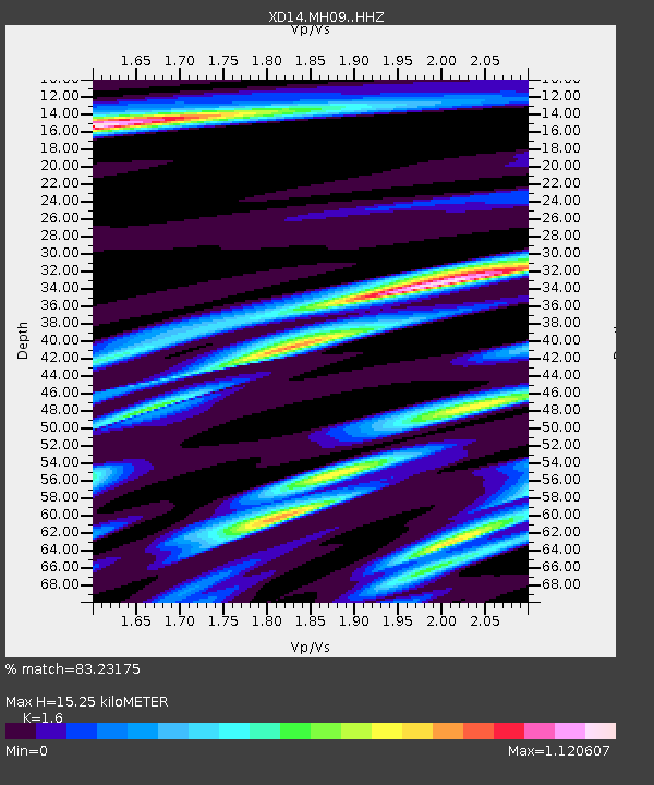
| Estimated Moho Depth: |
15.25 km |
| Estimated Crust Vp/Vs: |
1.60 |
| Assumed Crust Vp: |
6.597 km/s |
| Estimated Crust Vs: |
4.123 km/s |
| Estimated Crust Poisson's Ratio: |
0.18 |
|
| Radial Match: |
83.23175 % |
| Radial Bump: |
400 |
| Transverse Match: |
66.498795 % |
| Transverse Bump: |
400 |
| SOD ConfigId: |
3390531 |
| Insert Time: |
2019-04-13 08:53:39.298 +0000 |
| GWidth: |
2.5 |
| Max Bumps: |
400 |
| Tol: |
0.001 |
|

Signal To Noise
| Channel | StoN | STA | LTA |
| XD:MH09: :HHZ:20140813T06:54:40.005012Z | 9.934217 | 1.0674839E-6 | 1.0745526E-7 |
| XD:MH09: :HHN:20140813T06:54:40.005012Z | 4.45429 | 6.7047046E-7 | 1.505224E-7 |
| XD:MH09: :HHE:20140813T06:54:40.005012Z | 2.4269245 | 2.2672567E-7 | 9.342099E-8 |
| Arrivals |
| Ps | 1.5 SECOND |
| PpPs | 5.5 SECOND |
| PsPs/PpSs | 7.0 SECOND |


