You are here: Home > Network List > CN - Canadian National Seismograph Network Stations List
> Station INK INUVIK, NT > Earthquake Result Viewer
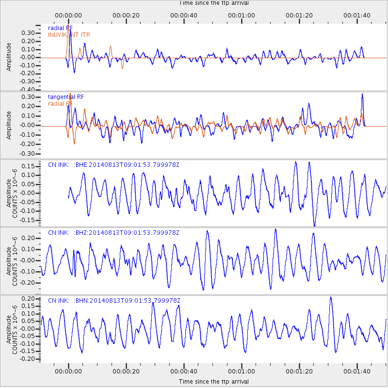
INK INUVIK, NT - Earthquake Result Viewer
*The percent match for this event was below the threshold and hence no stack was calculated.
| Earthquake location: |
E. Caroline Islands, Micronesia |
| Earthquake latitude/longitude: |
1.0/146.2 |
| Earthquake time(UTC): |
2014/08/13 (225) 08:49:48 GMT |
| Earthquake Depth: |
16 km |
| Earthquake Magnitude: |
5.0 MW, 5.2 mb |
| Earthquake Catalog/Contributor: |
ISC/ISC |
|
| Network: |
CN Canadian National Seismograph Network |
| Station: |
INK INUVIK, NT |
| Lat/Lon: |
68.31 N/133.53 W |
| Elevation: |
44 m |
|
| Distance: |
85.5 deg |
| Az: |
21.566 deg |
| Baz: |
261.314 deg |
| Ray Param: |
$rayparam |
*The percent match for this event was below the threshold and hence was not used in the summary stack. |
|
| Radial Match: |
47.94987 % |
| Radial Bump: |
400 |
| Transverse Match: |
38.403305 % |
| Transverse Bump: |
400 |
| SOD ConfigId: |
3390531 |
| Insert Time: |
2019-04-13 08:57:15.678 +0000 |
| GWidth: |
2.5 |
| Max Bumps: |
400 |
| Tol: |
0.001 |
|
Signal To Noise
| Channel | StoN | STA | LTA |
| CN:INK: :BHZ:20140813T09:01:53.799978Z | 0.88866884 | 7.390579E-8 | 8.316461E-8 |
| CN:INK: :BHN:20140813T09:01:53.799978Z | 1.505332 | 1.0080043E-7 | 6.696226E-8 |
| CN:INK: :BHE:20140813T09:01:53.799978Z | 0.8638837 | 5.3561525E-8 | 6.200085E-8 |
| Arrivals |
| Ps | |
| PpPs | |
| PsPs/PpSs | |


