You are here: Home > Network List > UW - Pacific Northwest Regional Seismic Network Stations List
> Station DAVN Chrisman Ranch, Davenport, WA, USA > Earthquake Result Viewer
DAVN Chrisman Ranch, Davenport, WA, USA - Earthquake Result Viewer
| Earthquake location: |
Kuril Islands |
| Earthquake latitude/longitude: |
46.0/151.5 |
| Earthquake time(UTC): |
2009/04/07 (097) 04:23:33 GMT |
| Earthquake Depth: |
31 km |
| Earthquake Magnitude: |
6.5 MB, 6.8 MS, 6.9 MW, 6.9 MW |
| Earthquake Catalog/Contributor: |
WHDF/NEIC |
|
| Network: |
UW Pacific Northwest Regional Seismic Network |
| Station: |
DAVN Chrisman Ranch, Davenport, WA, USA |
| Lat/Lon: |
47.80 N/118.27 W |
| Elevation: |
495 m |
|
| Distance: |
58.1 deg |
| Az: |
52.577 deg |
| Baz: |
304.875 deg |
| Ray Param: |
0.063016646 |
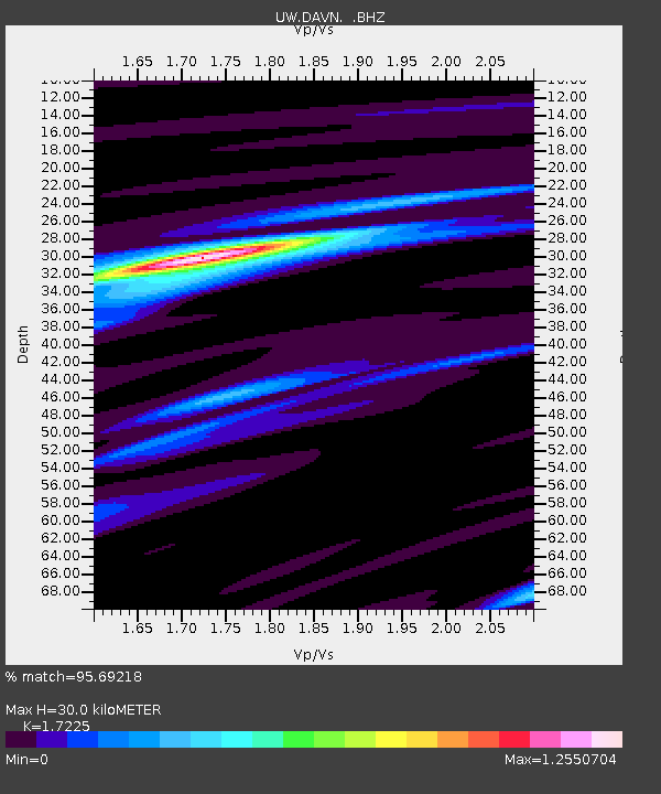
| Estimated Moho Depth: |
30.0 km |
| Estimated Crust Vp/Vs: |
1.72 |
| Assumed Crust Vp: |
6.419 km/s |
| Estimated Crust Vs: |
3.727 km/s |
| Estimated Crust Poisson's Ratio: |
0.25 |
|
| Radial Match: |
95.69218 % |
| Radial Bump: |
349 |
| Transverse Match: |
84.92912 % |
| Transverse Bump: |
400 |
| SOD ConfigId: |
2658 |
| Insert Time: |
2010-02-27 04:14:37.966 +0000 |
| GWidth: |
2.5 |
| Max Bumps: |
400 |
| Tol: |
0.001 |
|
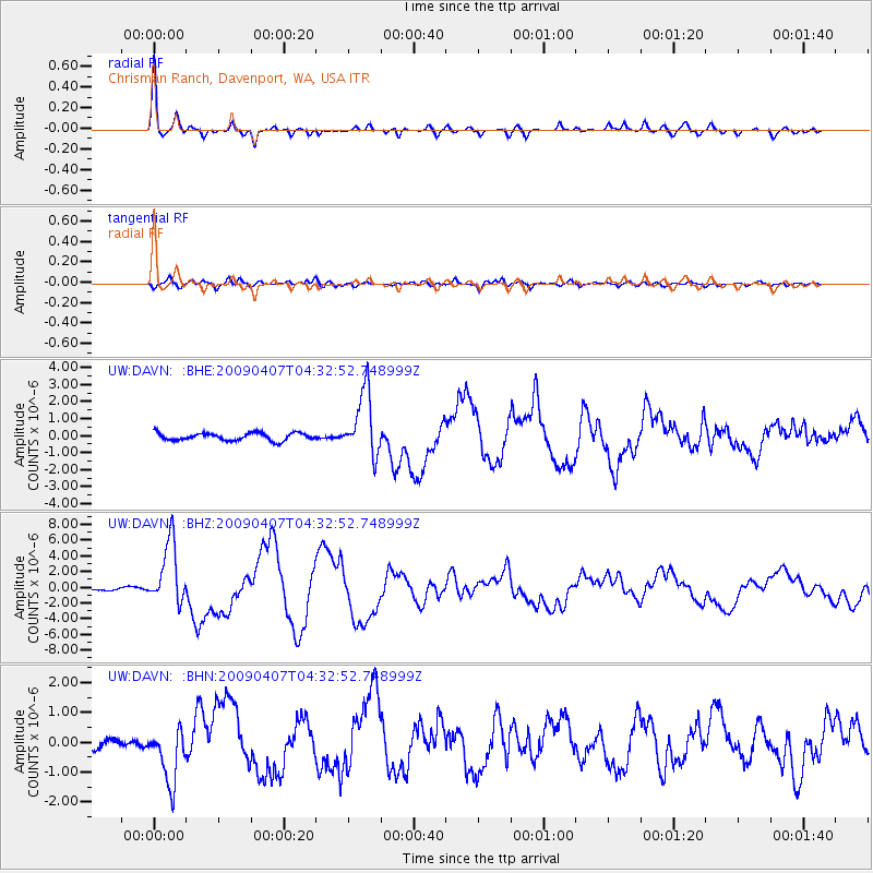
Signal To Noise
| Channel | StoN | STA | LTA |
| UW:DAVN: :BHZ:20090407T04:32:52.748999Z | 19.258331 | 3.9386173E-6 | 2.0451498E-7 |
| UW:DAVN: :BHN:20090407T04:32:52.748999Z | 4.9282236 | 9.3961825E-7 | 1.9066064E-7 |
| UW:DAVN: :BHE:20090407T04:32:52.748999Z | 8.527269 | 1.8720176E-6 | 2.1953308E-7 |
| Arrivals |
| Ps | 3.6 SECOND |
| PpPs | 12 SECOND |
| PsPs/PpSs | 16 SECOND |


