You are here: Home > Network List > IU - Global Seismograph Network (GSN - IRIS/USGS) Stations List
> Station KEV Kevo, Finland > Earthquake Result Viewer
KEV Kevo, Finland - Earthquake Result Viewer
| Earthquake location: |
Taiwan |
| Earthquake latitude/longitude: |
23.8/121.1 |
| Earthquake time(UTC): |
2013/06/02 (153) 05:43:03 GMT |
| Earthquake Depth: |
17 km |
| Earthquake Magnitude: |
6.2 MW, 6.1 MB, 6.2 MS, 6.2 MW |
| Earthquake Catalog/Contributor: |
NEIC PDE/NEIC PDE-W |
|
| Network: |
IU Global Seismograph Network (GSN - IRIS/USGS) |
| Station: |
KEV Kevo, Finland |
| Lat/Lon: |
69.76 N/27.00 E |
| Elevation: |
100 m |
|
| Distance: |
69.3 deg |
| Az: |
338.22 deg |
| Baz: |
77.559 deg |
| Ray Param: |
0.055706244 |
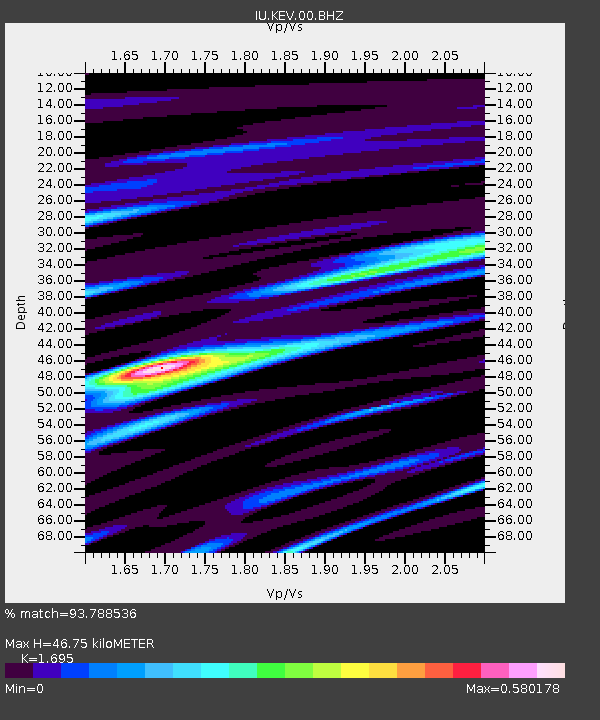
| Estimated Moho Depth: |
46.75 km |
| Estimated Crust Vp/Vs: |
1.70 |
| Assumed Crust Vp: |
6.622 km/s |
| Estimated Crust Vs: |
3.907 km/s |
| Estimated Crust Poisson's Ratio: |
0.23 |
|
| Radial Match: |
93.788536 % |
| Radial Bump: |
369 |
| Transverse Match: |
83.26152 % |
| Transverse Bump: |
400 |
| SOD ConfigId: |
512894 |
| Insert Time: |
2013-09-14 22:54:10.521 +0000 |
| GWidth: |
2.5 |
| Max Bumps: |
400 |
| Tol: |
0.001 |
|

Signal To Noise
| Channel | StoN | STA | LTA |
| IU:KEV:00:BHZ:20130602T05:53:38.668984Z | 8.136099 | 1.1239106E-6 | 1.3813876E-7 |
| IU:KEV:00:BH1:20130602T05:53:38.668984Z | 1.6941067 | 1.3910997E-7 | 8.2114056E-8 |
| IU:KEV:00:BH2:20130602T05:53:38.668984Z | 4.1398726 | 4.5432773E-7 | 1.0974438E-7 |
| Arrivals |
| Ps | 5.1 SECOND |
| PpPs | 18 SECOND |
| PsPs/PpSs | 23 SECOND |


