You are here: Home > Network List > TA - USArray Transportable Network (new EarthScope stations) Stations List
> Station P57A Homestead Farm, Martinsburg, WV, USA > Earthquake Result Viewer
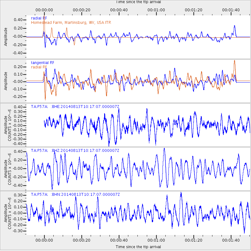
P57A Homestead Farm, Martinsburg, WV, USA - Earthquake Result Viewer
*The percent match for this event was below the threshold and hence no stack was calculated.
| Earthquake location: |
Central Mid-Atlantic Ridge |
| Earthquake latitude/longitude: |
0.8/-26.7 |
| Earthquake time(UTC): |
2014/08/13 (225) 10:07:28 GMT |
| Earthquake Depth: |
10 km |
| Earthquake Magnitude: |
5.5 MW, 5.4 mb, 5.2 Ms_20, 5.4 Mwb, 5.5 Mwc |
| Earthquake Catalog/Contributor: |
ISC/ISC |
|
| Network: |
TA USArray Transportable Network (new EarthScope stations) |
| Station: |
P57A Homestead Farm, Martinsburg, WV, USA |
| Lat/Lon: |
39.48 N/78.01 W |
| Elevation: |
191 m |
|
| Distance: |
60.5 deg |
| Az: |
316.026 deg |
| Baz: |
116.221 deg |
| Ray Param: |
$rayparam |
*The percent match for this event was below the threshold and hence was not used in the summary stack. |
|
| Radial Match: |
36.369858 % |
| Radial Bump: |
400 |
| Transverse Match: |
48.793503 % |
| Transverse Bump: |
400 |
| SOD ConfigId: |
3390531 |
| Insert Time: |
2019-04-13 09:07:43.916 +0000 |
| GWidth: |
2.5 |
| Max Bumps: |
400 |
| Tol: |
0.001 |
|
Signal To Noise
| Channel | StoN | STA | LTA |
| TA:P57A: :BHZ:20140813T10:17:07.000007Z | 1.1752987 | 1.7961318E-7 | 1.5282343E-7 |
| TA:P57A: :BHN:20140813T10:17:07.000007Z | 0.9106789 | 1.0637318E-7 | 1.1680645E-7 |
| TA:P57A: :BHE:20140813T10:17:07.000007Z | 1.869878 | 2.0612175E-7 | 1.1023272E-7 |
| Arrivals |
| Ps | |
| PpPs | |
| PsPs/PpSs | |


