You are here: Home > Network List > TA - USArray Transportable Network (new EarthScope stations) Stations List
> Station J01E Myrtle Point, OR, USA > Earthquake Result Viewer
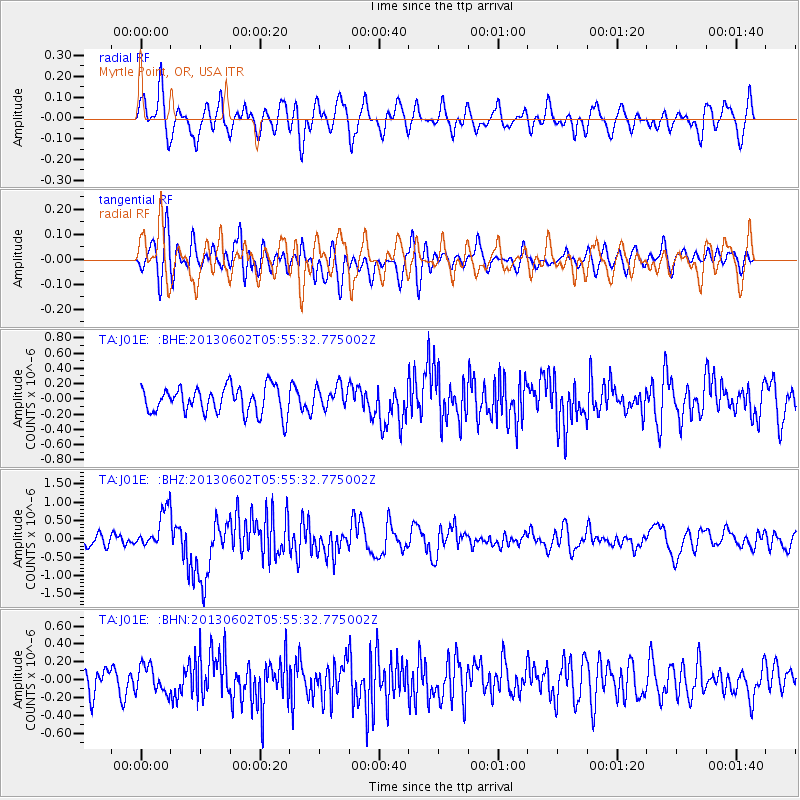
J01E Myrtle Point, OR, USA - Earthquake Result Viewer
*The percent match for this event was below the threshold and hence no stack was calculated.
| Earthquake location: |
Taiwan |
| Earthquake latitude/longitude: |
23.8/121.1 |
| Earthquake time(UTC): |
2013/06/02 (153) 05:43:03 GMT |
| Earthquake Depth: |
17 km |
| Earthquake Magnitude: |
6.2 MW, 6.1 MB, 6.2 MS, 6.2 MW |
| Earthquake Catalog/Contributor: |
NEIC PDE/NEIC PDE-W |
|
| Network: |
TA USArray Transportable Network (new EarthScope stations) |
| Station: |
J01E Myrtle Point, OR, USA |
| Lat/Lon: |
43.16 N/123.93 W |
| Elevation: |
128 m |
|
| Distance: |
90.5 deg |
| Az: |
41.573 deg |
| Baz: |
303.826 deg |
| Ray Param: |
$rayparam |
*The percent match for this event was below the threshold and hence was not used in the summary stack. |
|
| Radial Match: |
67.65743 % |
| Radial Bump: |
400 |
| Transverse Match: |
53.921032 % |
| Transverse Bump: |
400 |
| SOD ConfigId: |
512894 |
| Insert Time: |
2013-09-14 23:00:44.208 +0000 |
| GWidth: |
2.5 |
| Max Bumps: |
400 |
| Tol: |
0.001 |
|
Signal To Noise
| Channel | StoN | STA | LTA |
| TA:J01E: :BHZ:20130602T05:55:32.775002Z | 3.6557326 | 5.241864E-7 | 1.4338752E-7 |
| TA:J01E: :BHN:20130602T05:55:32.775002Z | 1.2074201 | 1.5624185E-7 | 1.294014E-7 |
| TA:J01E: :BHE:20130602T05:55:32.775002Z | 0.86206967 | 1.5088243E-7 | 1.7502346E-7 |
| Arrivals |
| Ps | |
| PpPs | |
| PsPs/PpSs | |


