You are here: Home > Network List > UW - Pacific Northwest Regional Seismic Network Stations List
> Station MRBL Marblemount, WA, USA > Earthquake Result Viewer
MRBL Marblemount, WA, USA - Earthquake Result Viewer
| Earthquake location: |
Taiwan |
| Earthquake latitude/longitude: |
23.8/121.1 |
| Earthquake time(UTC): |
2013/06/02 (153) 05:43:03 GMT |
| Earthquake Depth: |
17 km |
| Earthquake Magnitude: |
6.2 MW, 6.1 MB, 6.2 MS, 6.2 MW |
| Earthquake Catalog/Contributor: |
NEIC PDE/NEIC PDE-W |
|
| Network: |
UW Pacific Northwest Regional Seismic Network |
| Station: |
MRBL Marblemount, WA, USA |
| Lat/Lon: |
48.52 N/121.48 W |
| Elevation: |
75 m |
|
| Distance: |
88.9 deg |
| Az: |
36.195 deg |
| Baz: |
305.55 deg |
| Ray Param: |
0.042245995 |
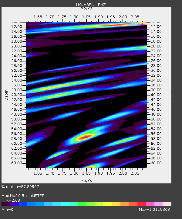
| Estimated Moho Depth: |
10.5 km |
| Estimated Crust Vp/Vs: |
2.08 |
| Assumed Crust Vp: |
6.566 km/s |
| Estimated Crust Vs: |
3.157 km/s |
| Estimated Crust Poisson's Ratio: |
0.35 |
|
| Radial Match: |
87.89907 % |
| Radial Bump: |
400 |
| Transverse Match: |
79.43516 % |
| Transverse Bump: |
400 |
| SOD ConfigId: |
512894 |
| Insert Time: |
2013-09-14 23:03:09.415 +0000 |
| GWidth: |
2.5 |
| Max Bumps: |
400 |
| Tol: |
0.001 |
|
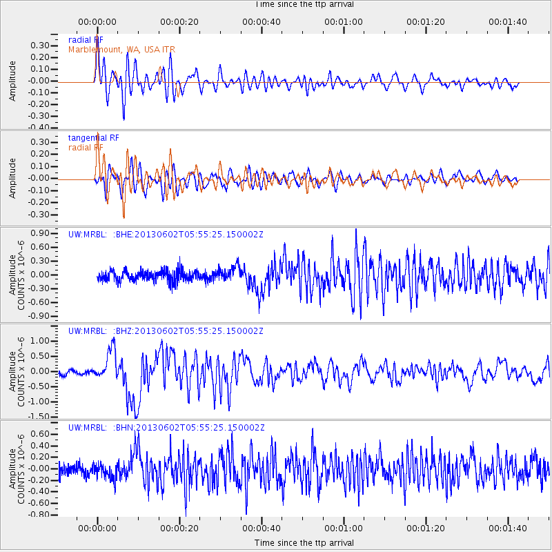
Signal To Noise
| Channel | StoN | STA | LTA |
| UW:MRBL: :BHZ:20130602T05:55:25.150002Z | 7.5234437 | 5.2775744E-7 | 7.014839E-8 |
| UW:MRBL: :BHN:20130602T05:55:25.150002Z | 1.1046053 | 1.2798824E-7 | 1.15867856E-7 |
| UW:MRBL: :BHE:20130602T05:55:25.150002Z | 1.4960246 | 1.6292005E-7 | 1.0890198E-7 |
| Arrivals |
| Ps | 1.8 SECOND |
| PpPs | 4.8 SECOND |
| PsPs/PpSs | 6.6 SECOND |


