You are here: Home > Network List > UW - Pacific Northwest Regional Seismic Network Stations List
> Station OMAK Colville Reservation, Omak, WA, USA > Earthquake Result Viewer
OMAK Colville Reservation, Omak, WA, USA - Earthquake Result Viewer
| Earthquake location: |
Taiwan |
| Earthquake latitude/longitude: |
23.8/121.1 |
| Earthquake time(UTC): |
2013/06/02 (153) 05:43:03 GMT |
| Earthquake Depth: |
17 km |
| Earthquake Magnitude: |
6.2 MW, 6.1 MB, 6.2 MS, 6.2 MW |
| Earthquake Catalog/Contributor: |
NEIC PDE/NEIC PDE-W |
|
| Network: |
UW Pacific Northwest Regional Seismic Network |
| Station: |
OMAK Colville Reservation, Omak, WA, USA |
| Lat/Lon: |
48.36 N/119.33 W |
| Elevation: |
696 m |
|
| Distance: |
90.1 deg |
| Az: |
35.475 deg |
| Baz: |
307.149 deg |
| Ray Param: |
0.041694388 |
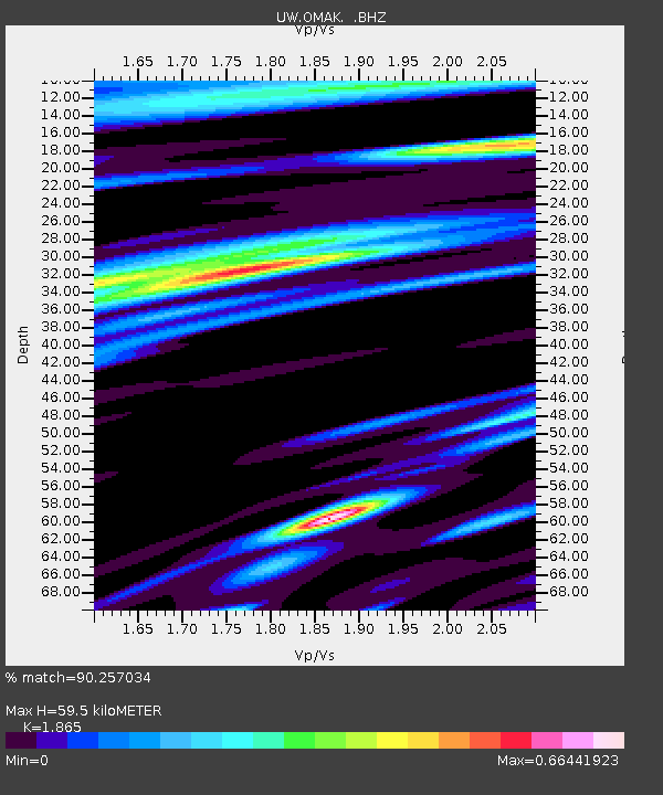
| Estimated Moho Depth: |
59.5 km |
| Estimated Crust Vp/Vs: |
1.87 |
| Assumed Crust Vp: |
6.419 km/s |
| Estimated Crust Vs: |
3.442 km/s |
| Estimated Crust Poisson's Ratio: |
0.30 |
|
| Radial Match: |
90.257034 % |
| Radial Bump: |
400 |
| Transverse Match: |
74.60056 % |
| Transverse Bump: |
400 |
| SOD ConfigId: |
512894 |
| Insert Time: |
2013-09-14 23:03:10.406 +0000 |
| GWidth: |
2.5 |
| Max Bumps: |
400 |
| Tol: |
0.001 |
|
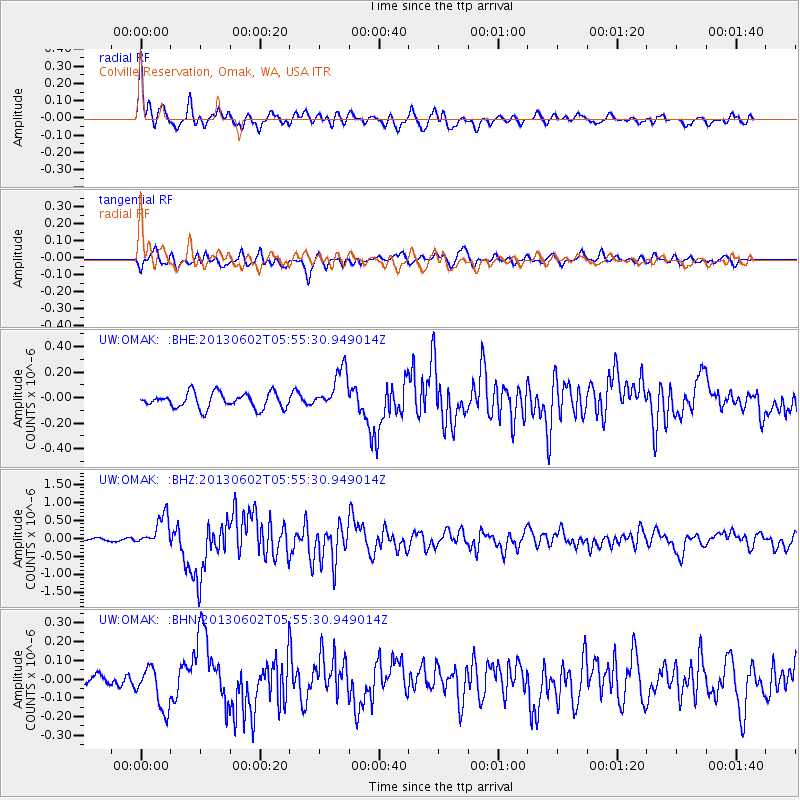
Signal To Noise
| Channel | StoN | STA | LTA |
| UW:OMAK: :BHZ:20130602T05:55:30.949014Z | 5.962287 | 4.2440018E-7 | 7.118077E-8 |
| UW:OMAK: :BHN:20130602T05:55:30.949014Z | 3.1278703 | 1.1321879E-7 | 3.6196766E-8 |
| UW:OMAK: :BHE:20130602T05:55:30.949014Z | 2.7392905 | 1.6344332E-7 | 5.96663E-8 |
| Arrivals |
| Ps | 8.2 SECOND |
| PpPs | 26 SECOND |
| PsPs/PpSs | 34 SECOND |


