You are here: Home > Network List > YE11 - Testing TA and FA Vaults and Directly Buried Sensors (3T) Stations List
> Station PIC3 Poker Flats, Alaska, USA > Earthquake Result Viewer
PIC3 Poker Flats, Alaska, USA - Earthquake Result Viewer
| Earthquake location: |
Taiwan |
| Earthquake latitude/longitude: |
23.8/121.1 |
| Earthquake time(UTC): |
2013/06/02 (153) 05:43:03 GMT |
| Earthquake Depth: |
17 km |
| Earthquake Magnitude: |
6.2 MW, 6.1 MB, 6.2 MS, 6.2 MW |
| Earthquake Catalog/Contributor: |
NEIC PDE/NEIC PDE-W |
|
| Network: |
YE Testing TA and FA Vaults and Directly Buried Sensors (3T) |
| Station: |
PIC3 Poker Flats, Alaska, USA |
| Lat/Lon: |
65.12 N/147.43 W |
| Elevation: |
502 m |
|
| Distance: |
69.3 deg |
| Az: |
26.885 deg |
| Baz: |
281.743 deg |
| Ray Param: |
0.055737574 |
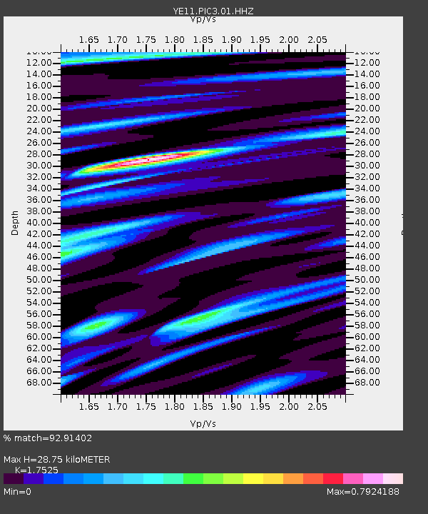
| Estimated Moho Depth: |
28.75 km |
| Estimated Crust Vp/Vs: |
1.75 |
| Assumed Crust Vp: |
6.566 km/s |
| Estimated Crust Vs: |
3.747 km/s |
| Estimated Crust Poisson's Ratio: |
0.26 |
|
| Radial Match: |
92.91402 % |
| Radial Bump: |
390 |
| Transverse Match: |
80.923454 % |
| Transverse Bump: |
400 |
| SOD ConfigId: |
512894 |
| Insert Time: |
2013-09-14 23:04:21.162 +0000 |
| GWidth: |
2.5 |
| Max Bumps: |
400 |
| Tol: |
0.001 |
|

Signal To Noise
| Channel | StoN | STA | LTA |
| YE:PIC3:01:HHZ:20130602T05:53:38.374978Z | 11.53709 | 7.26997E-7 | 6.301389E-8 |
| YE:PIC3:01:HHN:20130602T05:53:38.374978Z | 0.90731657 | 6.3922414E-8 | 7.045216E-8 |
| YE:PIC3:01:HHE:20130602T05:53:38.374978Z | 5.8515368 | 2.830696E-7 | 4.837526E-8 |
| Arrivals |
| Ps | 3.4 SECOND |
| PpPs | 12 SECOND |
| PsPs/PpSs | 15 SECOND |


