You are here: Home > Network List > GO - National Seismic Network of Georgia Stations List
> Station TBLG Delisi, Georgia > Earthquake Result Viewer
TBLG Delisi, Georgia - Earthquake Result Viewer
| Earthquake location: |
Mindanao, Philippines |
| Earthquake latitude/longitude: |
7.3/124.9 |
| Earthquake time(UTC): |
2013/06/02 (153) 20:08:26 GMT |
| Earthquake Depth: |
10 km |
| Earthquake Magnitude: |
5.6 MW, 5.5 MW, 5.8 MB |
| Earthquake Catalog/Contributor: |
NEIC PDE/NEIC PDE-W |
|
| Network: |
GO National Seismic Network of Georgia |
| Station: |
TBLG Delisi, Georgia |
| Lat/Lon: |
41.73 N/44.74 E |
| Elevation: |
510 m |
|
| Distance: |
77.9 deg |
| Az: |
311.029 deg |
| Baz: |
91.046 deg |
| Ray Param: |
0.050023932 |
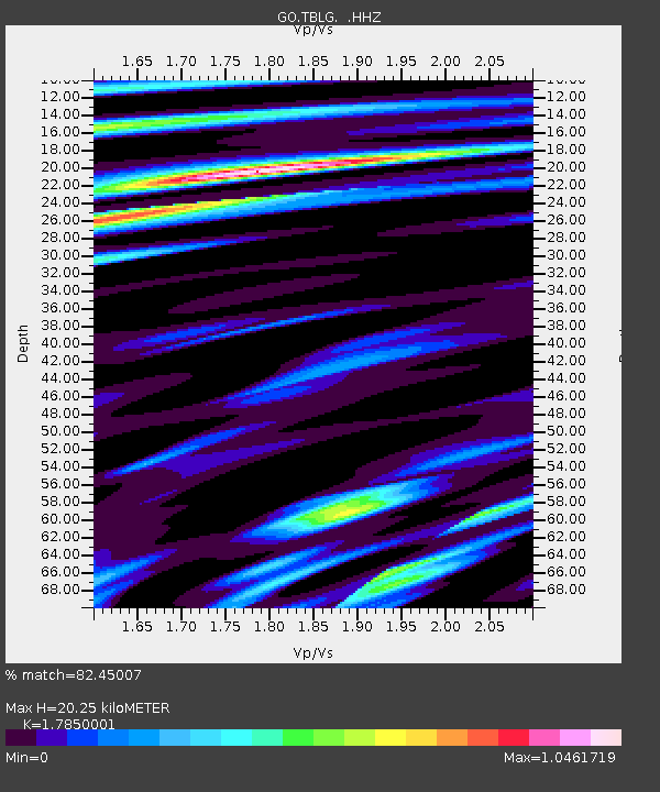
| Estimated Moho Depth: |
20.25 km |
| Estimated Crust Vp/Vs: |
1.79 |
| Assumed Crust Vp: |
6.291 km/s |
| Estimated Crust Vs: |
3.524 km/s |
| Estimated Crust Poisson's Ratio: |
0.27 |
|
| Radial Match: |
82.45007 % |
| Radial Bump: |
400 |
| Transverse Match: |
79.95317 % |
| Transverse Bump: |
400 |
| SOD ConfigId: |
512894 |
| Insert Time: |
2013-09-14 23:11:28.594 +0000 |
| GWidth: |
2.5 |
| Max Bumps: |
400 |
| Tol: |
0.001 |
|

Signal To Noise
| Channel | StoN | STA | LTA |
| GO:TBLG: :HHZ:20130602T20:19:52.999973Z | 7.2143946 | 3.6235332E-7 | 5.0226433E-8 |
| GO:TBLG: :HHN:20130602T20:19:52.999973Z | 1.7943709 | 8.3701465E-8 | 4.664669E-8 |
| GO:TBLG: :HHE:20130602T20:19:52.999973Z | 2.365013 | 1.10348694E-7 | 4.6658812E-8 |
| Arrivals |
| Ps | 2.6 SECOND |
| PpPs | 8.7 SECOND |
| PsPs/PpSs | 11 SECOND |


