You are here: Home > Network List > TA - USArray Transportable Network (new EarthScope stations) Stations List
> Station Y52A Lilburn, GA, USA > Earthquake Result Viewer
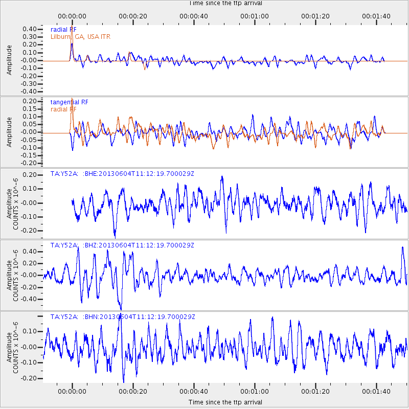
Y52A Lilburn, GA, USA - Earthquake Result Viewer
*The percent match for this event was below the threshold and hence no stack was calculated.
| Earthquake location: |
Kuril Islands |
| Earthquake latitude/longitude: |
45.4/150.9 |
| Earthquake time(UTC): |
2013/06/04 (155) 11:00:09 GMT |
| Earthquake Depth: |
24 km |
| Earthquake Magnitude: |
5.6 MW, 5.5 MW |
| Earthquake Catalog/Contributor: |
NEIC PDE/NEIC PDE-W |
|
| Network: |
TA USArray Transportable Network (new EarthScope stations) |
| Station: |
Y52A Lilburn, GA, USA |
| Lat/Lon: |
33.86 N/84.06 W |
| Elevation: |
286 m |
|
| Distance: |
86.7 deg |
| Az: |
43.044 deg |
| Baz: |
324.68 deg |
| Ray Param: |
$rayparam |
*The percent match for this event was below the threshold and hence was not used in the summary stack. |
|
| Radial Match: |
53.30664 % |
| Radial Bump: |
400 |
| Transverse Match: |
59.224476 % |
| Transverse Bump: |
400 |
| SOD ConfigId: |
512894 |
| Insert Time: |
2013-09-15 00:00:53.772 +0000 |
| GWidth: |
2.5 |
| Max Bumps: |
400 |
| Tol: |
0.001 |
|
Signal To Noise
| Channel | StoN | STA | LTA |
| TA:Y52A: :BHZ:20130604T11:12:19.700029Z | 2.39222 | 2.0941148E-7 | 8.753856E-8 |
| TA:Y52A: :BHN:20130604T11:12:19.700029Z | 1.0591283 | 6.579668E-8 | 6.2123426E-8 |
| TA:Y52A: :BHE:20130604T11:12:19.700029Z | 1.2403857 | 8.085983E-8 | 6.518926E-8 |
| Arrivals |
| Ps | |
| PpPs | |
| PsPs/PpSs | |


