You are here: Home > Network List > TA - USArray Transportable Network (new EarthScope stations) Stations List
> Station Z51A Franklin, GA, USA > Earthquake Result Viewer
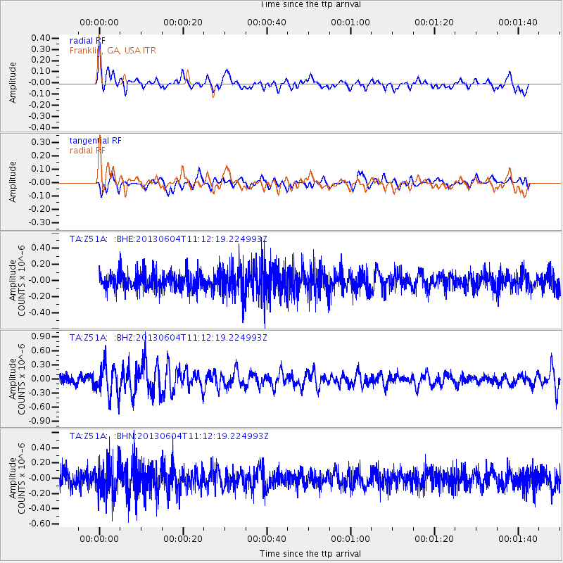
Z51A Franklin, GA, USA - Earthquake Result Viewer
*The percent match for this event was below the threshold and hence no stack was calculated.
| Earthquake location: |
Kuril Islands |
| Earthquake latitude/longitude: |
45.4/150.9 |
| Earthquake time(UTC): |
2013/06/04 (155) 11:00:09 GMT |
| Earthquake Depth: |
24 km |
| Earthquake Magnitude: |
5.6 MW, 5.5 MW |
| Earthquake Catalog/Contributor: |
NEIC PDE/NEIC PDE-W |
|
| Network: |
TA USArray Transportable Network (new EarthScope stations) |
| Station: |
Z51A Franklin, GA, USA |
| Lat/Lon: |
33.32 N/85.17 W |
| Elevation: |
249 m |
|
| Distance: |
86.6 deg |
| Az: |
44.118 deg |
| Baz: |
324.129 deg |
| Ray Param: |
$rayparam |
*The percent match for this event was below the threshold and hence was not used in the summary stack. |
|
| Radial Match: |
64.94046 % |
| Radial Bump: |
400 |
| Transverse Match: |
69.13433 % |
| Transverse Bump: |
400 |
| SOD ConfigId: |
512894 |
| Insert Time: |
2013-09-15 00:01:16.349 +0000 |
| GWidth: |
2.5 |
| Max Bumps: |
400 |
| Tol: |
0.001 |
|
Signal To Noise
| Channel | StoN | STA | LTA |
| TA:Z51A: :BHZ:20130604T11:12:19.224993Z | 3.072459 | 3.163137E-7 | 1.0295132E-7 |
| TA:Z51A: :BHN:20130604T11:12:19.224993Z | 1.9902352 | 2.1557172E-7 | 1.08314694E-7 |
| TA:Z51A: :BHE:20130604T11:12:19.224993Z | 1.5991669 | 1.7343797E-7 | 1.08455204E-7 |
| Arrivals |
| Ps | |
| PpPs | |
| PsPs/PpSs | |


