You are here: Home > Network List > US - United States National Seismic Network Stations List
> Station MSO Missoula, Montana, USA > Earthquake Result Viewer
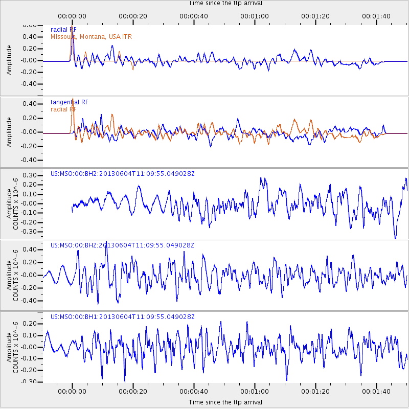
MSO Missoula, Montana, USA - Earthquake Result Viewer
*The percent match for this event was below the threshold and hence no stack was calculated.
| Earthquake location: |
Kuril Islands |
| Earthquake latitude/longitude: |
45.4/150.9 |
| Earthquake time(UTC): |
2013/06/04 (155) 11:00:09 GMT |
| Earthquake Depth: |
24 km |
| Earthquake Magnitude: |
5.6 MW, 5.5 MW |
| Earthquake Catalog/Contributor: |
NEIC PDE/NEIC PDE-W |
|
| Network: |
US United States National Seismic Network |
| Station: |
MSO Missoula, Montana, USA |
| Lat/Lon: |
46.83 N/113.94 W |
| Elevation: |
1264 m |
|
| Distance: |
61.8 deg |
| Az: |
50.885 deg |
| Baz: |
307.209 deg |
| Ray Param: |
$rayparam |
*The percent match for this event was below the threshold and hence was not used in the summary stack. |
|
| Radial Match: |
66.77862 % |
| Radial Bump: |
400 |
| Transverse Match: |
51.767742 % |
| Transverse Bump: |
400 |
| SOD ConfigId: |
512894 |
| Insert Time: |
2013-09-15 00:03:07.280 +0000 |
| GWidth: |
2.5 |
| Max Bumps: |
400 |
| Tol: |
0.001 |
|
Signal To Noise
| Channel | StoN | STA | LTA |
| US:MSO:00:BHZ:20130604T11:09:55.049028Z | 2.6490269 | 1.702398E-7 | 6.426503E-8 |
| US:MSO:00:BH1:20130604T11:09:55.049028Z | 0.78512037 | 5.332451E-8 | 6.79189E-8 |
| US:MSO:00:BH2:20130604T11:09:55.049028Z | 1.3435134 | 8.499481E-8 | 6.3263094E-8 |
| Arrivals |
| Ps | |
| PpPs | |
| PsPs/PpSs | |


