You are here: Home > Network List > UW - Pacific Northwest Regional Seismic Network Stations List
> Station FISH Seaside, OR, USA > Earthquake Result Viewer
FISH Seaside, OR, USA - Earthquake Result Viewer
*The percent match for this event was below the threshold and hence no stack was calculated.
| Earthquake location: |
Near Coast Of Peru |
| Earthquake latitude/longitude: |
-15.7/-74.8 |
| Earthquake time(UTC): |
2009/05/18 (138) 14:01:04 GMT |
| Earthquake Depth: |
23 km |
| Earthquake Magnitude: |
5.5 MS, 5.3 MB, 5.8 MW, 5.8 MW |
| Earthquake Catalog/Contributor: |
WHDF/NEIC |
|
| Network: |
UW Pacific Northwest Regional Seismic Network |
| Station: |
FISH Seaside, OR, USA |
| Lat/Lon: |
45.93 N/123.56 W |
| Elevation: |
325 m |
|
| Distance: |
75.4 deg |
| Az: |
327.185 deg |
| Baz: |
131.582 deg |
| Ray Param: |
$rayparam |
*The percent match for this event was below the threshold and hence was not used in the summary stack. |
|
| Radial Match: |
50.199966 % |
| Radial Bump: |
400 |
| Transverse Match: |
43.506737 % |
| Transverse Bump: |
400 |
| SOD ConfigId: |
2760 |
| Insert Time: |
2010-02-27 04:17:02.902 +0000 |
| GWidth: |
2.5 |
| Max Bumps: |
400 |
| Tol: |
0.001 |
|
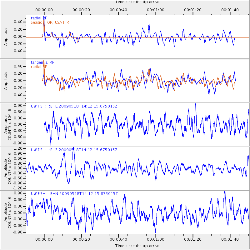
Signal To Noise
| Channel | StoN | STA | LTA |
| UW:FISH: :BHZ:20090518T14:12:15.675015Z | 0.82516974 | 1.649919E-7 | 1.9994904E-7 |
| UW:FISH: :BHN:20090518T14:12:15.675015Z | 1.6621567 | 5.6903565E-7 | 3.4234776E-7 |
| UW:FISH: :BHE:20090518T14:12:15.675015Z | 1.1713518 | 3.5995254E-7 | 3.072967E-7 |
| Arrivals |
| Ps | |
| PpPs | |
| PsPs/PpSs | |


