You are here: Home > Network List > UW - Pacific Northwest Regional Seismic Network Stations List
> Station FISH Seaside, OR, USA > Earthquake Result Viewer
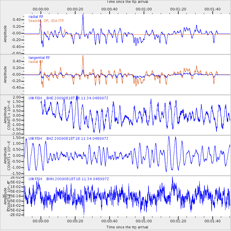
FISH Seaside, OR, USA - Earthquake Result Viewer
*The percent match for this event was below the threshold and hence no stack was calculated.
| Earthquake location: |
Solomon Islands |
| Earthquake latitude/longitude: |
-6.6/154.6 |
| Earthquake time(UTC): |
2009/08/18 (230) 17:59:13 GMT |
| Earthquake Depth: |
35 km |
| Earthquake Magnitude: |
5.6 MW, 5.4 MS, 5.3 MB, 5.6 MW |
| Earthquake Catalog/Contributor: |
WHDF/NEIC |
|
| Network: |
UW Pacific Northwest Regional Seismic Network |
| Station: |
FISH Seaside, OR, USA |
| Lat/Lon: |
45.93 N/123.56 W |
| Elevation: |
325 m |
|
| Distance: |
89.1 deg |
| Az: |
43.71 deg |
| Baz: |
259.59 deg |
| Ray Param: |
$rayparam |
*The percent match for this event was below the threshold and hence was not used in the summary stack. |
|
| Radial Match: |
54.155518 % |
| Radial Bump: |
400 |
| Transverse Match: |
54.46894 % |
| Transverse Bump: |
400 |
| SOD ConfigId: |
2622 |
| Insert Time: |
2010-02-27 04:17:13.548 +0000 |
| GWidth: |
2.5 |
| Max Bumps: |
400 |
| Tol: |
0.001 |
|
Signal To Noise
| Channel | StoN | STA | LTA |
| UW:FISH: :BHZ:20090818T18:11:34.048997Z | 1.2645609 | 7.523516E-7 | 5.9495085E-7 |
| UW:FISH: :BHN:20090818T18:11:34.048997Z | 1.1204727 | 5.85739E-9 | 5.2276063E-9 |
| UW:FISH: :BHE:20090818T18:11:34.048997Z | 1.735892 | 1.4069235E-6 | 8.1049023E-7 |
| Arrivals |
| Ps | |
| PpPs | |
| PsPs/PpSs | |


