You are here: Home > Network List > IW - Intermountain West Stations List
> Station MOOW Moose Ponds, Wyoming, USA > Earthquake Result Viewer
MOOW Moose Ponds, Wyoming, USA - Earthquake Result Viewer
*The percent match for this event was below the threshold and hence no stack was calculated.
| Earthquake location: |
Mariana Islands |
| Earthquake latitude/longitude: |
17.0/145.8 |
| Earthquake time(UTC): |
2013/06/04 (155) 14:03:10 GMT |
| Earthquake Depth: |
16 km |
| Earthquake Magnitude: |
5.5 MW, 5.8 MB |
| Earthquake Catalog/Contributor: |
NEIC PDE/NEIC PDE-W |
|
| Network: |
IW Intermountain West |
| Station: |
MOOW Moose Ponds, Wyoming, USA |
| Lat/Lon: |
43.75 N/110.74 W |
| Elevation: |
2128 m |
|
| Distance: |
87.8 deg |
| Az: |
44.864 deg |
| Baz: |
291.333 deg |
| Ray Param: |
$rayparam |
*The percent match for this event was below the threshold and hence was not used in the summary stack. |
|
| Radial Match: |
60.272556 % |
| Radial Bump: |
400 |
| Transverse Match: |
72.688286 % |
| Transverse Bump: |
400 |
| SOD ConfigId: |
512894 |
| Insert Time: |
2013-09-15 00:19:16.444 +0000 |
| GWidth: |
2.5 |
| Max Bumps: |
400 |
| Tol: |
0.001 |
|
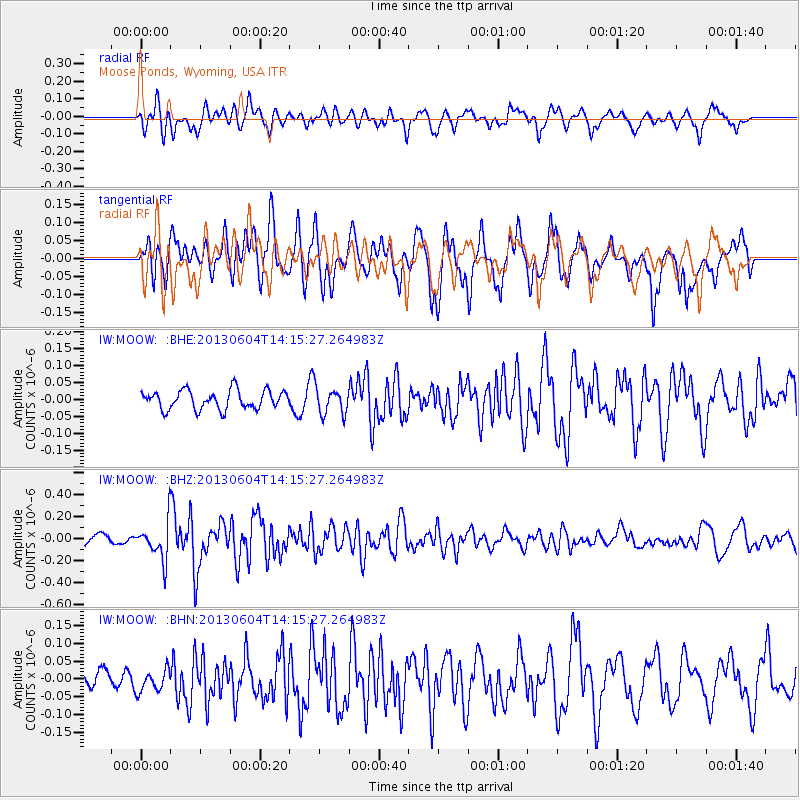
Signal To Noise
| Channel | StoN | STA | LTA |
| IW:MOOW: :BHZ:20130604T14:15:27.264983Z | 2.373822 | 1.6822244E-7 | 7.086565E-8 |
| IW:MOOW: :BHN:20130604T14:15:27.264983Z | 0.79286563 | 3.022807E-8 | 3.8125084E-8 |
| IW:MOOW: :BHE:20130604T14:15:27.264983Z | 1.453295 | 4.0248644E-8 | 2.769475E-8 |
| Arrivals |
| Ps | |
| PpPs | |
| PsPs/PpSs | |


