You are here: Home > Network List > TA - USArray Transportable Network (new EarthScope stations) Stations List
> Station J04D Umpqua National Forest, Toketee, OR, USA > Earthquake Result Viewer
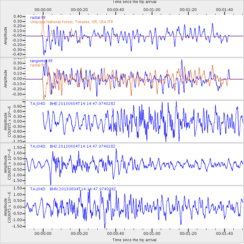
J04D Umpqua National Forest, Toketee, OR, USA - Earthquake Result Viewer
*The percent match for this event was below the threshold and hence no stack was calculated.
| Earthquake location: |
Mariana Islands |
| Earthquake latitude/longitude: |
17.0/145.8 |
| Earthquake time(UTC): |
2013/06/04 (155) 14:03:10 GMT |
| Earthquake Depth: |
16 km |
| Earthquake Magnitude: |
5.5 MW, 5.8 MB |
| Earthquake Catalog/Contributor: |
NEIC PDE/NEIC PDE-W |
|
| Network: |
TA USArray Transportable Network (new EarthScope stations) |
| Station: |
J04D Umpqua National Forest, Toketee, OR, USA |
| Lat/Lon: |
43.24 N/122.11 W |
| Elevation: |
1948 m |
|
| Distance: |
80.0 deg |
| Az: |
47.858 deg |
| Baz: |
283.844 deg |
| Ray Param: |
$rayparam |
*The percent match for this event was below the threshold and hence was not used in the summary stack. |
|
| Radial Match: |
61.662018 % |
| Radial Bump: |
400 |
| Transverse Match: |
57.034138 % |
| Transverse Bump: |
400 |
| SOD ConfigId: |
512894 |
| Insert Time: |
2013-09-15 00:24:35.687 +0000 |
| GWidth: |
2.5 |
| Max Bumps: |
400 |
| Tol: |
0.001 |
|
Signal To Noise
| Channel | StoN | STA | LTA |
| TA:J04D: :BHZ:20130604T14:14:47.974028Z | 1.9258295 | 5.6900745E-7 | 2.9546098E-7 |
| TA:J04D: :BHN:20130604T14:14:47.974028Z | 1.8458011 | 4.5083266E-7 | 2.442477E-7 |
| TA:J04D: :BHE:20130604T14:14:47.974028Z | 0.90026057 | 3.233194E-7 | 3.591398E-7 |
| Arrivals |
| Ps | |
| PpPs | |
| PsPs/PpSs | |


